Czermin geodata
Czermin (Subcarpathian) is a populated place; located in Poland in Europe/Warsaw (GMT+2) time zone. With population of 1,557 people, there are 1799 cities with bigger population in this country. Compared to other cities in Poland, 71.1% of cities are located further ↑North; 77.3% of cities are located further ←West and 54.2% of cities have higher elevation than Czermin. Note1


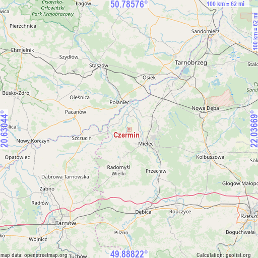
Czermin GPS coordinates[2]
50° 20' 20.796" North, 21° 20' 0.816" East
| Map corner | latitude | longitude |
|---|---|---|
| Upper-left | 50.78576°, | 20.63044° |
| Center: | 50.33911°, | 21.33356° |
| Lower-right: | 49.88822°, | 22.03669° |
| Map W x H: | 99.8×99.8 km | = 62×62mi |
| max Lat: | 54.83135° ⇑71.1% North |
| Czermin: | 50.33911° |
| min Lat: | ⇓28.9% South 49.21328° |
| min Long | Czermin | max Long |
| 14.20249° | 21.33356° | 24.03723° |
| W 77.3%⇐ | ⇒22.7% E |
Elevation
Elevation of Czermin is 161 m = 528 ft, and this is 30.4 m = 100 ft below average elevation for this country.
| Max E: |
974 m = 3196 ft | 54.2% |
| Avg. | 191.4 m = 628 ft | |
| Czermin | 161 m = 528 ft | |
Min E: |
-3 m = -10 ft | 45.8% |
See also: Poland elevation on elevation.city.
Geographical zone
Czermin is located in North temperate zone (between Tropic of Cancer and the Arctic Circle). Distance of this North polar circle is 1804 km =1121 mi to North.| Distance of | km | miles | from Czermin |
|---|---|---|---|
| North Pole | 4409.9 | 2740.2 | to North |
| Arctic Circle | 1804 | 1121 | to North |
| Tropic Cancer | 2991.3 | 1858.7 | to South |
| Equator | 5597.2 | 3477.9 | to South |


Nearby cities:
15 places around Czermin: (largest is in red/bold)
• Borowa
5.3 km =3.3 mi,  13°
13°
• Błonie
17.6 km =10.9 mi,  142°
142°
• Gawłuszowice
9 km =5.6 mi,  22°
22°
• Mielec
8.6 km =5.3 mi,  132°
132°
• Padew Narodowa
16.3 km =10.1 mi,  46°
46°
• Połaniec
11.1 km =6.9 mi,  340°
340°
• Przecław
19.3 km =12 mi,  147°
147°
• Przyłęk
20.6 km =12.8 mi,  109°
109°
• Radomyśl Wielki
16.3 km =10.1 mi,  194°
194°
• Szczucin
18.7 km =11.6 mi,  259°
259°
• Słupiec
10 km =6.2 mi, 262°
• Trzciana
3.5 km =2.2 mi,  175°
175°
• Tuszów Narodowy
9.6 km =6 mi,  67°
67°
• Wadowice Górne
8.7 km =5.4 mi, 194°
• Łubnice
15.3 km =9.5 mi,  301°
301°
Sources, notices
• [Note1] Compared only with cities in Poland existing in our database
• [Src1] Map data: © OpenStreetMap contributors (CC-BY-SA)
• [Src2] Other city data from geonames.org with taken over terms of usage.
• [Src3] Geographical zone / Annual Mean Temperature by Robert A. Rohde @ Wikipedia
