Tuszów Narodowy geodata
Tuszów Narodowy (Subcarpathian) is a populated place; located in Poland in Europe/Warsaw (GMT+2) time zone. With population of 920 people, there are 2637 cities with bigger population in this country. Compared to other cities in Poland, 70.3% of cities are located further ↑North; 78.7% of cities are located further ←West and 55.6% of cities have higher elevation than Tuszów Narodowy. Note1
Administrative division(s):
- Level 1: Subcarpathian
- Level 2: Powiat mielecki
- Level 3: Tuszów Narodowy


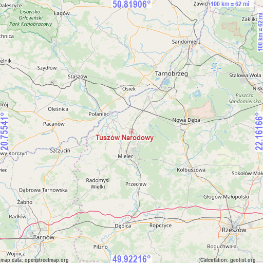
Tuszów Narodowy GPS coordinates[2]
50° 22' 21.828" North, 21° 27' 30.708" East
| Map corner | latitude | longitude |
|---|---|---|
| Upper-left | 50.81906°, | 20.75541° |
| Center: | 50.37273°, | 21.45853° |
| Lower-right: | 49.92216°, | 22.16166° |
| Map W x H: | 99.7×99.7 km | = 62×62mi |
| max Lat: | 54.83135° ⇑70.3% North |
| Tuszów Narodowy: | 50.37273° |
| min Lat: | ⇓29.7% South 49.21328° |
| min Long | Tuszów Narodow | max Long |
| 14.20249° | 21.45853° | 24.03723° |
| W 78.7%⇐ | ⇒21.3% E |
Elevation
Elevation of Tuszów Narodowy is 157 m = 515 ft, and this is 34.4 m = 113 ft below average elevation for this country.
| Max E: |
974 m = 3196 ft | 55.6% |
| Avg. | 191.4 m = 628 ft | |
| Tuszów Narodowy | 157 m = 515 ft | |
Min E: |
-3 m = -10 ft | 44.4% |
See also: Poland elevation on elevation.city.
Geographical zone
Tuszów Narodowy is located in North temperate zone (between Tropic of Cancer and the Arctic Circle). Distance of this North polar circle is 1800.3 km =1118.7 mi to North.| Distance of | km | miles | from Tuszów Narodowy |
|---|---|---|---|
| North Pole | 4406.1 | 2737.8 | to North |
| Arctic Circle | 1800.3 | 1118.7 | to North |
| Tropic Cancer | 2995 | 1861 | to South |
| Equator | 5600.9 | 3480.2 | to South |


Nearby cities:
15 places around Tuszów Narodowy: (largest is in red/bold)
• Baranów Sandomierski
15.2 km =9.4 mi,  22°
22°
• Borowa
7.7 km =4.8 mi,  280°
280°
• Błonie
17.8 km =11.1 mi,  174°
174°
• Czermin
9.6 km =6 mi,  247°
247°
• Gawłuszowice
7 km =4.3 mi,  310°
310°
• Mielec
9.8 km =6.1 mi,  194°
194°
• Osiek
16.4 km =10.2 mi,  355°
355°
• Ostrowy Baranowskie
14.7 km =9.1 mi,  105°
105°
• Ostrowy Tuszowskie
15 km =9.3 mi, 113°
• Padew Narodowa
8 km =5 mi, 21°
• Połaniec
14.3 km =8.9 mi,  298°
298°
• Przyłęk
15 km =9.3 mi,  135°
135°
• Trzciana
11.2 km =7 mi,  229°
229°
• Wadowice Górne
16.5 km =10.3 mi,  222°
222°
• Świniary Stare
19 km =11.8 mi, 15°
Sources, notices
• [Note1] Compared only with cities in Poland existing in our database
• [Src1] Map data: © OpenStreetMap contributors (CC-BY-SA)
• [Src2] Other city data from geonames.org with taken over terms of usage.
• [Src3] Geographical zone / Annual Mean Temperature by Robert A. Rohde @ Wikipedia
