Białołeka geodata
Białołeka (Mazovia) is a populated place; located in Poland in Europe/Warsaw (GMT+2) time zone. With population of 89,324 people, there are 53 cities with bigger population in this country. Compared to other cities in Poland, 73.1% of cities are located further ↓South; 72.2% of cities are located further ←West and 88.4% of cities have higher elevation than Białołeka. Note1


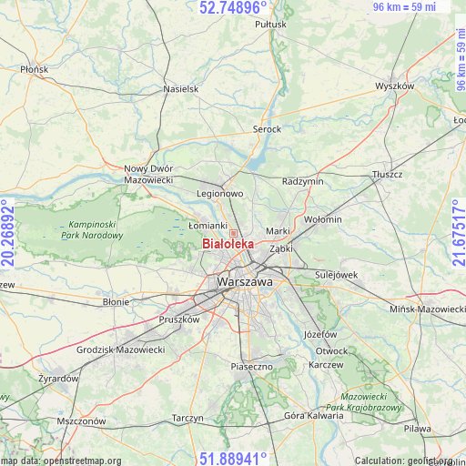
Białołeka GPS coordinates[2]
52° 19' 16.572" North, 20° 58' 19.344" East
| Map corner | latitude | longitude |
|---|---|---|
| Upper-left | 52.74896°, | 20.26892° |
| Center: | 52.32127°, | 20.97204° |
| Lower-right: | 51.88941°, | 21.67517° |
| Map W x H: | 95.6×95.6 km | = 59.4×59.4mi |
| max Lat: | 54.83135° ⇑26.9% North |
| Białołeka: | 52.32127° |
| min Lat: | ⇓73.1% South 49.21328° |
| min Long | Białołeka | max Long |
| 14.20249° | 20.97204° | 24.03723° |
| W 72.2%⇐ | ⇒27.8% E |
Elevation
Elevation of Białołeka is 80 m = 262 ft, and this is 111.4 m = 365 ft below average elevation for this country.
| Max E: |
974 m = 3196 ft | 88.4% |
| Avg. | 191.4 m = 628 ft | |
| Białołeka | 80 m = 262 ft | |
Min E: |
-3 m = -10 ft | 11.6% |
See also: Białołeka elevation on elevation.city.
Geographical zone
Białołeka is located in North temperate zone (between Tropic of Cancer and the Arctic Circle). Distance of this North polar circle is 1583.6 km =984 mi to North.| Distance of | km | miles | from Białołeka |
|---|---|---|---|
| North Pole | 4189.5 | 2603.2 | to North |
| Arctic Circle | 1583.6 | 984 | to North |
| Tropic Cancer | 3211.7 | 1995.7 | to South |
| Equator | 5817.6 | 3614.9 | to South |


Nearby cities:
15 places around Białołeka: (largest is in red/bold)
• Bemowo
8.6 km =5.3 mi,  210°
210°
• Bielany
4.1 km =2.5 mi,  217°
217°
• Dziekanów Bajkowy
9.2 km =5.7 mi,  296°
296°
• Dziekanów Leśny
8.9 km =5.5 mi,  292°
292°
• Jabłonna
7.4 km =4.6 mi,  329°
329°
• Kiełpin
8.5 km =5.3 mi, 298°
• Legionowo
9.4 km =5.8 mi,  340°
340°
• Marki
9 km =5.6 mi,  90°
90°
• Praga Północ
8.6 km =5.3 mi,  150°
150°
• Stanisławów Pierwszy
8.1 km =5 mi,  42°
42°
• Targówek
6.1 km =3.8 mi,  122°
122°
• Wola
9.1 km =5.7 mi,  172°
172°
• Ząbki
9.6 km =6 mi,  109°
109°
• Łomianki
6 km =3.7 mi,  283°
283°
• Żoliborz
5.9 km =3.7 mi, 170°
Sources, notices
• [Note1] Compared only with cities in Poland existing in our database
• [Src1] Map data: © OpenStreetMap contributors (CC-BY-SA)
• [Src2] Other city data from geonames.org with taken over terms of usage.
• [Src3] Geographical zone / Annual Mean Temperature by Robert A. Rohde @ Wikipedia
