Marki geodata
Marki (Mazovia) is a seat of a third-order administrative division; located in Poland in Europe/Warsaw (GMT+2) time zone. With population of 23,177 people, there are 211 cities with bigger population in this country. Compared to other cities in Poland, 73.1% of cities are located further ↓South; 74.5% of cities are located further ←West and 86.1% of cities have higher elevation than Marki. Note1


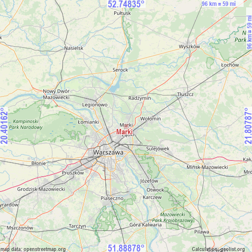
Marki GPS coordinates[2]
52° 19' 14.34" North, 21° 6' 17.064" East
| Map corner | latitude | longitude |
|---|---|---|
| Upper-left | 52.74835°, | 20.40162° |
| Center: | 52.32065°, | 21.10474° |
| Lower-right: | 51.88878°, | 21.80787° |
| Map W x H: | 95.6×95.6 km | = 59.4×59.4mi |
| max Lat: | 54.83135° ⇑26.9% North |
| Marki: | 52.32065° |
| min Lat: | ⇓73.1% South 49.21328° |
| min Long | Marki | max Long |
| 14.20249° | 21.10474° | 24.03723° |
| W 74.5%⇐ | ⇒25.5% E |
Elevation
Elevation of Marki is 87 m = 285 ft, and this is 104.4 m = 343 ft below average elevation for this country.
| Max E: |
974 m = 3196 ft | 86.1% |
| Avg. | 191.4 m = 628 ft | |
| Marki | 87 m = 285 ft | |
Min E: |
-3 m = -10 ft | 13.9% |
See also: Poland elevation on elevation.city.
Geographical zone
Marki is located in North temperate zone (between Tropic of Cancer and the Arctic Circle). Distance of this North polar circle is 1583.7 km =984.1 mi to North.| Distance of | km | miles | from Marki |
|---|---|---|---|
| North Pole | 4189.6 | 2603.3 | to North |
| Arctic Circle | 1583.7 | 984.1 | to North |
| Tropic Cancer | 3211.6 | 1995.6 | to South |
| Equator | 5817.5 | 3614.8 | to South |


Nearby cities:
15 places around Marki: (largest is in red/bold)
• Białołeka
9 km =5.6 mi,  270°
270°
• Czarna
9.8 km =6.1 mi,  57°
57°
• Kobyłka
6.5 km =4 mi,  71°
71°
• Praga Południe
8.6 km =5.3 mi,  188°
188°
• Praga Północ
8.8 km =5.5 mi,  212°
212°
• Rembertów
7.8 km =4.8 mi,  149°
149°
• Stanisławów Pierwszy
7 km =4.3 mi,  329°
329°
• Słupno
7.9 km =4.9 mi,  26°
26°
• Targówek
5 km =3.1 mi,  230°
230°
• Wesoła
11 km =6.8 mi,  132°
132°
• Wołomin
9.6 km =6 mi,  76°
76°
• Zielonka
4.2 km =2.6 mi,  116°
116°
• Ząbki
3.1 km =1.9 mi,  179°
179°
• Śródmieście
11.8 km =7.3 mi, 210°
• Żoliborz
9.9 km =6.2 mi, 234°
Sources, notices
• [Note1] Compared only with cities in Poland existing in our database
• [Src1] Map data: © OpenStreetMap contributors (CC-BY-SA)
• [Src2] Other city data from geonames.org with taken over terms of usage.
• [Src3] Geographical zone / Annual Mean Temperature by Robert A. Rohde @ Wikipedia
