Stanisławów Pierwszy geodata
Stanisławów Pierwszy (Mazovia) is a populated place; located in Poland in Europe/Warsaw (GMT+2) time zone. With population of 1,176 people, there are 2233 cities with bigger population in this country. Compared to other cities in Poland, 74.2% of cities are located further ↓South; 73.6% of cities are located further ←West and 88.9% of cities have higher elevation than Stanisławów Pierwszy. Note1


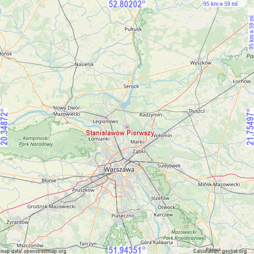
Stanisławów Pierwszy GPS coordinates[2]
52° 22' 29.46" North, 21° 3' 6.624" East
| Map corner | latitude | longitude |
|---|---|---|
| Upper-left | 52.80202°, | 20.34872° |
| Center: | 52.37485°, | 21.05184° |
| Lower-right: | 51.94351°, | 21.75497° |
| Map W x H: | 95.5×95.5 km | = 59.3×59.3mi |
| max Lat: | 54.83135° ⇑25.8% North |
| Stanisławów Pierwszy: | 52.37485° |
| min Lat: | ⇓74.2% South 49.21328° |
| min Long | Stanisławów P | max Long |
| 14.20249° | 21.05184° | 24.03723° |
| W 73.6%⇐ | ⇒26.4% E |
Elevation
Elevation of Stanisławów Pierwszy is 79 m = 259 ft, and this is 112.4 m = 369 ft below average elevation for this country.
| Max E: |
974 m = 3196 ft | 88.9% |
| Avg. | 191.4 m = 628 ft | |
| Stanisławów Pierwszy | 79 m = 259 ft | |
Min E: |
-3 m = -10 ft | 11.1% |
See also: Poland elevation on elevation.city.
Geographical zone
Stanisławów Pierwszy is located in North temperate zone (between Tropic of Cancer and the Arctic Circle). Distance of this North polar circle is 1577.6 km =980.3 mi to North.| Distance of | km | miles | from Stanisławów Pierwszy |
|---|---|---|---|
| North Pole | 4183.5 | 2599.5 | to North |
| Arctic Circle | 1577.6 | 980.3 | to North |
| Tropic Cancer | 3217.6 | 1999.3 | to South |
| Equator | 5823.5 | 3618.6 | to South |


Nearby cities:
15 places around Stanisławów Pierwszy: (largest is in red/bold)
• Białobrzegi
7.5 km =4.7 mi,  0°
0°
• Białołeka
8.1 km =5 mi,  222°
222°
• Jabłonna
9.1 km =5.7 mi,  272°
272°
• Kobyłka
10.5 km =6.5 mi,  111°
111°
• Legionowo
9 km =5.6 mi,  289°
289°
• Marki
7 km =4.3 mi,  149°
149°
• Michałów-Reginów
7.5 km =4.7 mi,  308°
308°
• Nieporęt
6.4 km =4 mi,  348°
348°
• Radzymin
10.1 km =6.3 mi,  63°
63°
• Stanisławów
7.2 km =4.5 mi,  304°
304°
• Słupno
7.1 km =4.4 mi,  81°
81°
• Targówek
9.2 km =5.7 mi,  181°
181°
• Wieliszew
10.2 km =6.3 mi,  326°
326°
• Ząbki
9.8 km =6.1 mi,  158°
158°
• Łajski
9.2 km =5.7 mi, 310°
Sources, notices
• [Note1] Compared only with cities in Poland existing in our database
• [Src1] Map data: © OpenStreetMap contributors (CC-BY-SA)
• [Src2] Other city data from geonames.org with taken over terms of usage.
• [Src3] Geographical zone / Annual Mean Temperature by Robert A. Rohde @ Wikipedia
