Drelów geodata
Drelów (Lublin) is a seat of a third-order administrative division; located in Poland in Europe/Warsaw (GMT+2) time zone. With population of 900 people, there are 2674 cities with bigger population in this country. Compared to other cities in Poland, 63.9% of cities are located further ↓South; 95% of cities are located further ←West and 59.5% of cities have higher elevation than Drelów. Note1


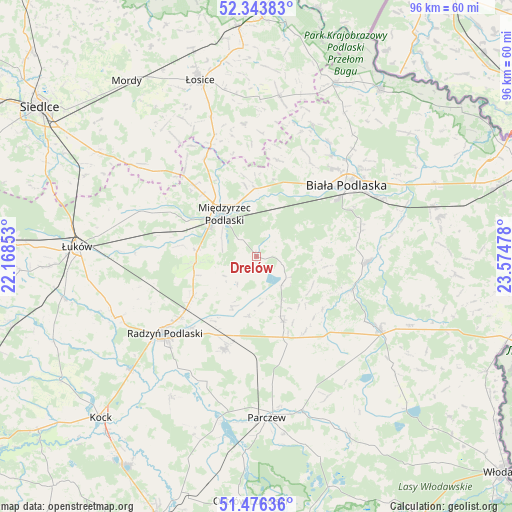
Drelów GPS coordinates[2]
51° 54' 43.884" North, 22° 52' 17.94" East
| Map corner | latitude | longitude |
|---|---|---|
| Upper-left | 52.34383°, | 22.16853° |
| Center: | 51.91219°, | 22.87165° |
| Lower-right: | 51.47636°, | 23.57478° |
| Map W x H: | 96.5×96.5 km | = 60×60mi |
| max Lat: | 54.83135° ⇑36.1% North |
| Drelów: | 51.91219° |
| min Lat: | ⇓63.9% South 49.21328° |
| min Long | Drelów | max Long |
| 14.20249° | 22.87165° | 24.03723° |
| W 95%⇐ | ⇒5% E |
Elevation
Elevation of Drelów is 148 m = 486 ft, and this is 43.4 m = 142 ft below average elevation for this country.
| Max E: |
974 m = 3196 ft | 59.5% |
| Avg. | 191.4 m = 628 ft | |
| Drelów | 148 m = 486 ft | |
Min E: |
-3 m = -10 ft | 40.5% |
See also: Poland elevation on elevation.city.
Geographical zone
Drelów is located in North temperate zone (between Tropic of Cancer and the Arctic Circle). Distance of this North polar circle is 1629.1 km =1012.3 mi to North.| Distance of | km | miles | from Drelów |
|---|---|---|---|
| North Pole | 4235 | 2631.5 | to North |
| Arctic Circle | 1629.1 | 1012.3 | to North |
| Tropic Cancer | 3166.2 | 1967.4 | to South |
| Equator | 5772.1 | 3586.6 | to South |


Nearby cities:
15 places around Drelów: (largest is in red/bold)
• Biała Podlaska
21.4 km =13.3 mi,  51°
51°
• Huszlew
25.3 km =15.7 mi,  354°
354°
• Jabłoń
25.6 km =15.9 mi,  144°
144°
• Komarówka Podlaska
13.1 km =8.1 mi,  157°
157°
• Kostry
24.2 km =15 mi,  172°
172°
• Kąkolewnica Wschodnia
11.3 km =7 mi,  265°
265°
• Leśna Podlaska
26.8 km =16.7 mi,  23°
23°
• Milanów
23.2 km =14.4 mi,  177°
177°
• Międzyrzec Podlaski
10.3 km =6.4 mi,  323°
323°
• Radzyń Podlaski
22.6 km =14 mi,  230°
230°
• Rossosz
19.2 km =11.9 mi,  108°
108°
• Rzeczyca
10.1 km =6.3 mi,  303°
303°
• Trzebieszów
23.4 km =14.5 mi,  291°
291°
• Wohyń
18.3 km =11.4 mi,  198°
198°
• Łomazy
20.9 km =13 mi,  92°
92°
Sources, notices
• [Note1] Compared only with cities in Poland existing in our database
• [Src1] Map data: © OpenStreetMap contributors (CC-BY-SA)
• [Src2] Other city data from geonames.org with taken over terms of usage.
• [Src3] Geographical zone / Annual Mean Temperature by Robert A. Rohde @ Wikipedia
