Barahona geodata
Barahona (Morovis) is a populated place; located in Puerto Rico in America/Puerto_Rico (GMT-4) time zone. With population of 2,632 people, there are 111 cities with bigger population in this country. Compared to other cities in Puerto Rico, 64.4% of cities are located further ↓South; 58.7% of cities are located further →East and 82.2% of cities have lower elevation than Barahona. Note1


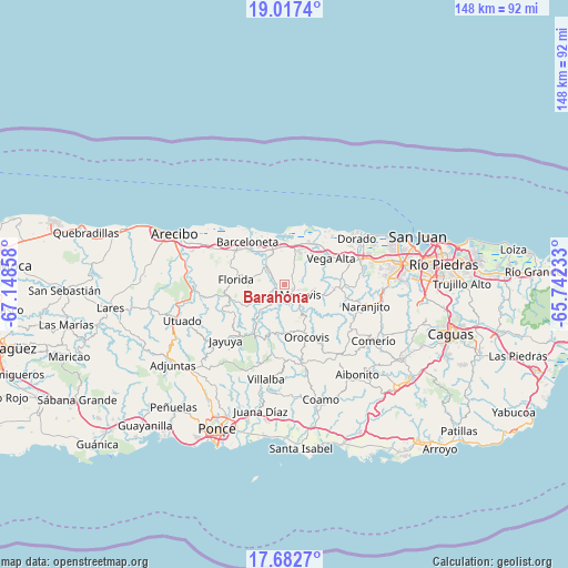
Barahona GPS coordinates[2]
18° 21' 4.824" North, 66° 26' 43.62" West
| Map corner | latitude | longitude |
|---|---|---|
| Upper-left | 19.0174°, | -67.14858° |
| Center: | 18.35134°, | -66.44545° |
| Lower-right: | 17.6827°, | -65.74233° |
| Map W x H: | 148.4×148.4 km | = 92.2×92.2mi |
| max Lat: | 18.50078° ⇑35.6% North |
| Barahona: | 18.35134° |
| min Lat: | ⇓64.4% South 17.95358° |
| min Long | Barahona | max Long |
| -67.2499° | -66.44545° | -65.30099° |
| W 41.3%⇐ | ⇒58.7% E |
Elevation
Elevation of Barahona is 166 m = 545 ft, and this is 65.5 m = 215 ft above average elevation for this country.
| Max E: |
655 m = 2149 ft | 17.8% |
| Barahona | 166 m 545 ft | |
| Avg. | 100.5 m = 330 ft | |
Min E: |
1 m = 3 ft | 82.2% |
See also: Puerto Rico elevation on elevation.city.
Geographical zone
Barahona is located in North Torrid zone (between Equator and Tropic of Cancer). Distance of this Northern Tropic circle is 565.4 km =351.3 mi to North.| Distance of | km | miles | from Barahona |
|---|---|---|---|
| North Pole | 7966.6 | 4950.2 | to North |
| Arctic Circle | 5360.7 | 3331 | to North |
| Tropic Cancer | 565.4 | 351.3 | to North |
| Equator | 2040.5 | 1267.9 | to South |


Nearby cities:
15 places around Barahona: (largest is in red/bold)
• Ciales
3 km =1.9 mi,  235°
235°
• Corozal
13.6 km =8.5 mi,  94°
94°
• Coto Norte
8.9 km =5.5 mi,  3°
3°
• Estancias de Florida
13.2 km =8.2 mi,  277°
277°
• Florida
12.3 km =7.6 mi, 275°
• Franquez
2.2 km =1.4 mi,  123°
123°
• La Luisa
12.8 km =8 mi,  327°
327°
• Manatí
9.8 km =6.1 mi, 329°
• Miranda
7.6 km =4.7 mi,  58°
58°
• Monserrate
13.1 km =8.1 mi,  43°
43°
• Morovis
5 km =3.1 mi, 124°
• Pajonal
12.1 km =7.5 mi,  286°
286°
• Tierras Nuevas Poniente
13.1 km =8.1 mi,  339°
339°
• Vega Alta
13.8 km =8.6 mi, 60°
• Vega Baja
12 km =7.5 mi,  30°
30°
Sources, notices
• [Note1] Compared only with cities in Puerto Rico existing in our database
• [Src1] Map data: © OpenStreetMap contributors (CC-BY-SA)
• [Src2] Other city data from geonames.org with taken over terms of usage.
• [Src3] Geographical zone / Annual Mean Temperature by Robert A. Rohde @ Wikipedia
