Vega Alta geodata
Vega Alta is a seat of a first-order administrative division; located in Puerto Rico in America/Puerto_Rico (GMT-4) time zone. With population of 12,036 people, there are 25 cities with bigger population in this country. Compared to other cities in Puerto Rico, 79.1% of cities are located further ↓South; 50.2% of cities are located further ←West and 57.8% of cities have higher elevation than Vega Alta. Note1


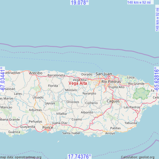
Vega Alta GPS coordinates[2]
18° 24' 43.812" North, 66° 19' 52.608" West
| Map corner | latitude | longitude |
|---|---|---|
| Upper-left | 19.078°, | -67.03441° |
| Center: | 18.41217°, | -66.33128° |
| Lower-right: | 17.74376°, | -65.62816° |
| Map W x H: | 148.4×148.4 km | = 92.2×92.2mi |
| max Lat: | 18.50078° ⇑20.9% North |
| Vega Alta: | 18.41217° |
| min Lat: | ⇓79.1% South 17.95358° |
| min Long | Vega Alta | max Long |
| -67.2499° | -66.33128° | -65.30099° |
| W 50.2%⇐ | ⇒49.8% E |
Elevation
Elevation of Vega Alta is 34 m = 112 ft, and this is 66.5 m = 218 ft below average elevation for this country.
| Max E: |
655 m = 2149 ft | 57.8% |
| Avg. | 100.5 m = 330 ft | |
| Vega Alta | 34 m = 112 ft | |
Min E: |
1 m = 3 ft | 42.2% |
See also: Puerto Rico elevation on elevation.city.
Geographical zone
Vega Alta is located in North Torrid zone (between Equator and Tropic of Cancer). Distance of this Northern Tropic circle is 558.7 km =347.2 mi to North.| Distance of | km | miles | from Vega Alta |
|---|---|---|---|
| North Pole | 7959.8 | 4946 | to North |
| Arctic Circle | 5353.9 | 3326.8 | to North |
| Tropic Cancer | 558.7 | 347.2 | to North |
| Equator | 2047.2 | 1272.1 | to South |


Nearby cities:
15 places around Vega Alta: (largest is in red/bold)
• Brenas
6.2 km =3.9 mi,  350°
350°
• Ceiba
4.3 km =2.7 mi,  331°
331°
• Corozal
8.1 km =5 mi,  169°
169°
• Dorado
8.5 km =5.3 mi,  52°
52°
• Galateo
9.4 km =5.8 mi,  125°
125°
• H. Rivera Colon
9.4 km =5.8 mi,  139°
139°
• Miranda
6.2 km =3.9 mi,  242°
242°
• Monserrate
4 km =2.5 mi,  312°
312°
• Río Lajas
7 km =4.3 mi,  106°
106°
• Sabana
6.1 km =3.8 mi, 332°
• San Antonio
5.1 km =3.2 mi,  36°
36°
• San José
8.1 km =5 mi,  100°
100°
• Toa Alta
9.2 km =5.7 mi, 106°
• Toa Baja
8.3 km =5.2 mi,  65°
65°
• Vega Baja
6.9 km =4.3 mi,  301°
301°
Sources, notices
• [Note1] Compared only with cities in Puerto Rico existing in our database
• [Src1] Map data: © OpenStreetMap contributors (CC-BY-SA)
• [Src2] Other city data from geonames.org with taken over terms of usage.
• [Src3] Geographical zone / Annual Mean Temperature by Robert A. Rohde @ Wikipedia
