Morovis geodata
Morovis is a seat of a first-order administrative division; located in Puerto Rico in America/Puerto_Rico (GMT-4) time zone. With population of 2,414 people, there are 115 cities with bigger population in this country. Compared to other cities in Puerto Rico, 60% of cities are located further ↓South; 56.4% of cities are located further →East and 88.4% of cities have lower elevation than Morovis. Note1


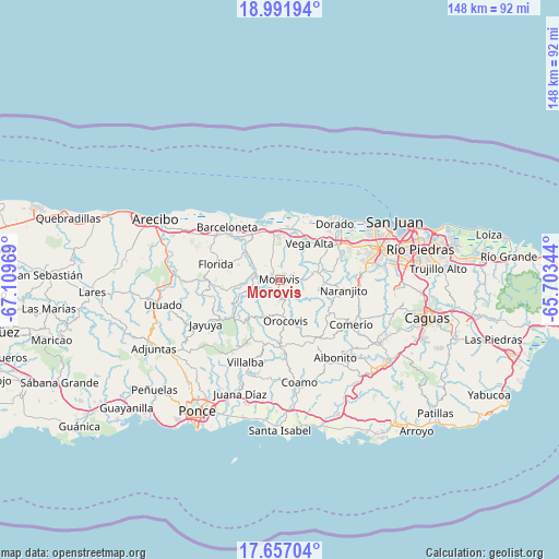
Morovis GPS coordinates[2]
18° 19' 32.808" North, 66° 24' 23.616" West
| Map corner | latitude | longitude |
|---|---|---|
| Upper-left | 18.99194°, | -67.10969° |
| Center: | 18.32578°, | -66.40656° |
| Lower-right: | 17.65704°, | -65.70344° |
| Map W x H: | 148.4×148.4 km | = 92.2×92.2mi |
| max Lat: | 18.50078° ⇑40% North |
| Morovis: | 18.32578° |
| min Lat: | ⇓60% South 17.95358° |
| min Long | Morovis | max Long |
| -67.2499° | -66.40656° | -65.30099° |
| W 43.6%⇐ | ⇒56.4% E |
Elevation
Elevation of Morovis is 219 m = 719 ft, and this is 118.5 m = 389 ft above average elevation for this country.
| Max E: |
655 m = 2149 ft | 11.6% |
| Morovis | 219 m 719 ft | |
| Avg. | 100.5 m = 330 ft | |
Min E: |
1 m = 3 ft | 88.4% |
See also: Puerto Rico elevation on elevation.city.
Geographical zone
Morovis is located in North Torrid zone (between Equator and Tropic of Cancer). Distance of this Northern Tropic circle is 568.3 km =353.1 mi to North.| Distance of | km | miles | from Morovis |
|---|---|---|---|
| North Pole | 7969.4 | 4952 | to North |
| Arctic Circle | 5363.5 | 3332.7 | to North |
| Tropic Cancer | 568.3 | 353.1 | to North |
| Equator | 2037.6 | 1266.1 | to South |


Nearby cities:
15 places around Morovis: (largest is in red/bold)
• Barahona
5 km =3.1 mi,  304°
304°
• Ceiba
14.6 km =9.1 mi,  23°
23°
• Ciales
6.7 km =4.2 mi,  279°
279°
• Corozal
9.6 km =6 mi,  79°
79°
• Coto Norte
12.2 km =7.6 mi,  343°
343°
• Franquez
2.7 km =1.7 mi,  305°
305°
• Galateo
16.1 km =10 mi, 75°
• H. Rivera Colon
14.2 km =8.8 mi, 80°
• Manatí
14.5 km =9 mi,  321°
321°
• Miranda
7.2 km =4.5 mi, 19°
• Monserrate
13.3 km =8.3 mi, 21°
• Orocovis
11.1 km =6.9 mi,  171°
171°
• Sabana
15.8 km =9.8 mi, 18°
• Vega Alta
12.5 km =7.8 mi,  39°
39°
• Vega Baja
13.3 km =8.3 mi,  8°
8°
Sources, notices
• [Note1] Compared only with cities in Puerto Rico existing in our database
• [Src1] Map data: © OpenStreetMap contributors (CC-BY-SA)
• [Src2] Other city data from geonames.org with taken over terms of usage.
• [Src3] Geographical zone / Annual Mean Temperature by Robert A. Rohde @ Wikipedia
