Vega Baja geodata
Vega Baja is a seat of a first-order administrative division; located in Puerto Rico in America/Puerto_Rico (GMT-4) time zone. With population of 29,325 people, there are 11 cities with bigger population in this country. Compared to other cities in Puerto Rico, 89.8% of cities are located further ↓South; 54.2% of cities are located further →East and 83.1% of cities have higher elevation than Vega Baja. Note1


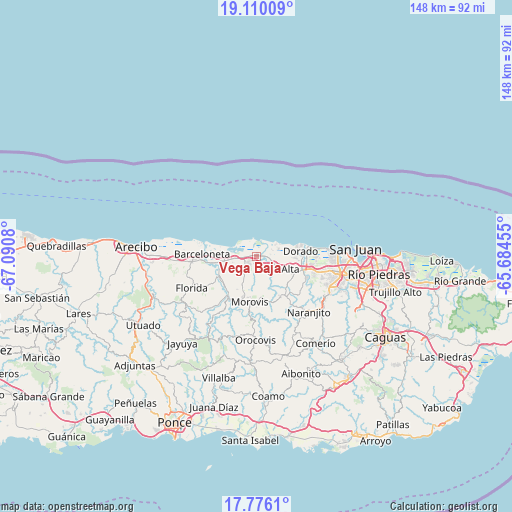
Vega Baja GPS coordinates[2]
18° 26' 39.804" North, 66° 23' 15.612" West
| Map corner | latitude | longitude |
|---|---|---|
| Upper-left | 19.11009°, | -67.0908° |
| Center: | 18.44439°, | -66.38767° |
| Lower-right: | 17.7761°, | -65.68455° |
| Map W x H: | 148.3×148.3 km | = 92.1×92.1mi |
| max Lat: | 18.50078° ⇑10.2% North |
| Vega Baja: | 18.44439° |
| min Lat: | ⇓89.8% South 17.95358° |
| min Long | Vega Baja | max Long |
| -67.2499° | -66.38767° | -65.30099° |
| W 45.8%⇐ | ⇒54.2% E |
Elevation
Elevation of Vega Baja is 12 m = 39 ft, and this is 88.5 m = 290 ft below average elevation for this country.
| Max E: |
655 m = 2149 ft | 83.1% |
| Avg. | 100.5 m = 330 ft | |
| Vega Baja | 12 m = 39 ft | |
Min E: |
1 m = 3 ft | 16.9% |
See also: Puerto Rico elevation on elevation.city.
Geographical zone
Vega Baja is located in North Torrid zone (between Equator and Tropic of Cancer). Distance of this Northern Tropic circle is 555.1 km =344.9 mi to North.| Distance of | km | miles | from Vega Baja |
|---|---|---|---|
| North Pole | 7956.2 | 4943.8 | to North |
| Arctic Circle | 5350.4 | 3324.6 | to North |
| Tropic Cancer | 555.1 | 344.9 | to North |
| Equator | 2050.8 | 1274.3 | to South |


Nearby cities:
15 places around Vega Baja: (largest is in red/bold)
• Barahona
12 km =7.5 mi,  210°
210°
• Brenas
5.5 km =3.4 mi,  62°
62°
• Ceiba
3.9 km =2.4 mi,  86°
86°
• Coto Norte
5.7 km =3.5 mi,  254°
254°
• Dorado
12.8 km =8 mi,  82°
82°
• Franquez
12.3 km =7.6 mi,  200°
200°
• La Luisa
12.9 km =8 mi,  272°
272°
• Manatí
11.2 km =7 mi,  260°
260°
• Miranda
6.4 km =4 mi,  176°
176°
• Monserrate
3.1 km =1.9 mi,  106°
106°
• Morovis
13.3 km =8.3 mi,  188°
188°
• Sabana
3.6 km =2.2 mi, 59°
• San Antonio
9 km =5.6 mi, 86°
• Tierras Nuevas Poniente
10.8 km =6.7 mi,  280°
280°
• Vega Alta
6.9 km =4.3 mi,  121°
121°
Sources, notices
• [Note1] Compared only with cities in Puerto Rico existing in our database
• [Src1] Map data: © OpenStreetMap contributors (CC-BY-SA)
• [Src2] Other city data from geonames.org with taken over terms of usage.
• [Src3] Geographical zone / Annual Mean Temperature by Robert A. Rohde @ Wikipedia
