Buena Vista geodata
Buena Vista (Arroyo) is a populated place; located in Puerto Rico in America/Puerto_Rico (GMT-4) time zone. With population of 2,026 people, there are 138 cities with bigger population in this country. Compared to other cities in Puerto Rico, 90.2% of cities are located further ↑North; 73.3% of cities are located further ←West and 53.3% of cities have lower elevation than Buena Vista. Note1


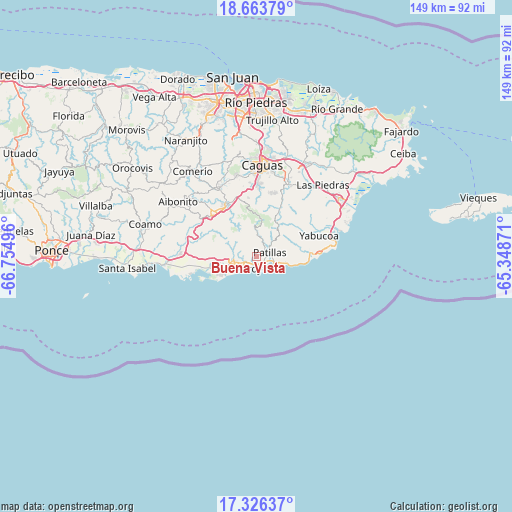
Buena Vista GPS coordinates[2]
17° 59' 46.86" North, 66° 3' 6.588" West
| Map corner | latitude | longitude |
|---|---|---|
| Upper-left | 18.66379°, | -66.75496° |
| Center: | 17.99635°, | -66.05183° |
| Lower-right: | 17.32637°, | -65.34871° |
| Map W x H: | 148.7×148.7 km | = 92.4×92.4mi |
| max Lat: | 18.50078° ⇑90.2% North |
| Buena Vista: | 17.99635° |
| min Lat: | ⇓9.8% South 17.95358° |
| min Long | Buena Vista | max Long |
| -67.2499° | -66.05183° | -65.30099° |
| W 73.3%⇐ | ⇒26.7% E |
Elevation
Elevation of Buena Vista is 55 m = 180 ft, and this is 45.5 m = 149 ft below average elevation for this country.
| Max E: |
655 m = 2149 ft | 46.7% |
| Avg. | 100.5 m = 330 ft | |
| Buena Vista | 55 m = 180 ft | |
Min E: |
1 m = 3 ft | 53.3% |
See also: Puerto Rico elevation on elevation.city.
Geographical zone
Buena Vista is located in North Torrid zone (between Equator and Tropic of Cancer). Distance of this Northern Tropic circle is 604.9 km =375.9 mi to North.| Distance of | km | miles | from Buena Vista |
|---|---|---|---|
| North Pole | 8006.1 | 4974.8 | to North |
| Arctic Circle | 5400.2 | 3355.5 | to North |
| Tropic Cancer | 604.9 | 375.9 | to North |
| Equator | 2001 | 1243.4 | to South |


Nearby cities:
15 places around Buena Vista: (largest is in red/bold)
• Arroyo
3.5 km =2.2 mi,  196°
196°
• Corazón
3.5 km =2.2 mi,  263°
263°
• G. L. Garcia
15.6 km =9.7 mi,  339°
339°
• Guayama
6.7 km =4.2 mi, 258°
• Jobos
12.9 km =8 mi,  249°
249°
• La Plena
17.1 km =10.6 mi,  289°
289°
• Lamboglia
7.2 km =4.5 mi,  103°
103°
• Maunabo
16.2 km =10.1 mi,  85°
85°
• Olimpo
6 km =3.7 mi,  275°
275°
• Palmas
3 km =1.9 mi,  110°
110°
• Palo Seco
12.2 km =7.6 mi,  84°
84°
• Patillas
4 km =2.5 mi,  73°
73°
• Playita
16.2 km =10.1 mi, 70°
• Rosa Sanchez
16.3 km =10.1 mi,  63°
63°
• Yaurel
3.4 km =2.1 mi,  350°
350°
Sources, notices
• [Note1] Compared only with cities in Puerto Rico existing in our database
• [Src1] Map data: © OpenStreetMap contributors (CC-BY-SA)
• [Src2] Other city data from geonames.org with taken over terms of usage.
• [Src3] Geographical zone / Annual Mean Temperature by Robert A. Rohde @ Wikipedia
