La Plena geodata
La Plena (Salinas) is a populated place; located in Puerto Rico in America/Puerto_Rico (GMT-4) time zone. With population of 1,036 people, there are 215 cities with bigger population in this country. Compared to other cities in Puerto Rico, 78.2% of cities are located further ↑North; 63.6% of cities are located further ←West and 84.9% of cities have lower elevation than La Plena. Note1


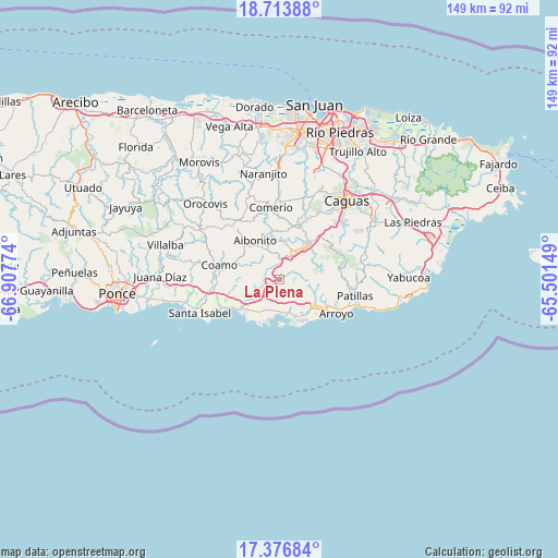
La Plena GPS coordinates[2]
18° 2' 47.868" North, 66° 12' 16.596" West
| Map corner | latitude | longitude |
|---|---|---|
| Upper-left | 18.71388°, | -66.90774° |
| Center: | 18.04663°, | -66.20461° |
| Lower-right: | 17.37684°, | -65.50149° |
| Map W x H: | 148.7×148.7 km | = 92.4×92.4mi |
| max Lat: | 18.50078° ⇑78.2% North |
| La Plena: | 18.04663° |
| min Lat: | ⇓21.8% South 17.95358° |
| min Long | La Plena | max Long |
| -67.2499° | -66.20461° | -65.30099° |
| W 63.6%⇐ | ⇒36.4% E |
Elevation
Elevation of La Plena is 183 m = 600 ft, and this is 82.5 m = 271 ft above average elevation for this country.
| Max E: |
655 m = 2149 ft | 15.1% |
| La Plena | 183 m 600 ft | |
| Avg. | 100.5 m = 330 ft | |
Min E: |
1 m = 3 ft | 84.9% |
See also: Puerto Rico elevation on elevation.city.
Geographical zone
La Plena is located in North Torrid zone (between Equator and Tropic of Cancer). Distance of this Northern Tropic circle is 599.3 km =372.4 mi to North.| Distance of | km | miles | from La Plena |
|---|---|---|---|
| North Pole | 8000.5 | 4971.3 | to North |
| Arctic Circle | 5394.6 | 3352 | to North |
| Tropic Cancer | 599.3 | 372.4 | to North |
| Equator | 2006.6 | 1246.8 | to South |


Nearby cities:
15 places around La Plena: (largest is in red/bold)
• Aibonito
12.2 km =7.6 mi,  327°
327°
• Cayey
8.3 km =5.2 mi,  29°
29°
• Central Aguirre
10.5 km =6.5 mi,  190°
190°
• Coco
7.3 km =4.5 mi,  232°
232°
• Coquí
8.4 km =5.2 mi,  196°
196°
• Guayama
11.9 km =7.4 mi,  125°
125°
• Jobos
11 km =6.8 mi,  157°
157°
• Las Ochenta
13.8 km =8.6 mi,  240°
240°
• Olimpo
11.3 km =7 mi,  116°
116°
• Palmarejo
13 km =8.1 mi,  280°
280°
• Parcelas Nuevas
11 km =6.8 mi,  18°
18°
• Pastos
9.8 km =6.1 mi,  324°
324°
• Playita
13.1 km =8.1 mi,  223°
223°
• Salinas
12.5 km =7.8 mi, 232°
• Vázquez
4.2 km =2.6 mi,  300°
300°
Sources, notices
• [Note1] Compared only with cities in Puerto Rico existing in our database
• [Src1] Map data: © OpenStreetMap contributors (CC-BY-SA)
• [Src2] Other city data from geonames.org with taken over terms of usage.
• [Src3] Geographical zone / Annual Mean Temperature by Robert A. Rohde @ Wikipedia
