Maunabo geodata
Maunabo is a seat of a first-order administrative division; located in Puerto Rico in America/Puerto_Rico (GMT-4) time zone. With population of 2,154 people, there are 130 cities with bigger population in this country. Compared to other cities in Puerto Rico, 87.6% of cities are located further ↑North; 81.8% of cities are located further ←West and 81.8% of cities have higher elevation than Maunabo. Note1


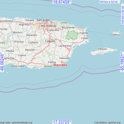
Maunabo GPS coordinates[2]
18° 0' 25.884" North, 65° 53' 57.588" West
| Map corner | latitude | longitude |
|---|---|---|
| Upper-left | 18.67459°, | -66.60246° |
| Center: | 18.00719°, | -65.89933° |
| Lower-right: | 17.33725°, | -65.19621° |
| Map W x H: | 148.7×148.7 km | = 92.4×92.4mi |
| max Lat: | 18.50078° ⇑87.6% North |
| Maunabo: | 18.00719° |
| min Lat: | ⇓12.4% South 17.95358° |
| min Long | Maunabo | max Long |
| -67.2499° | -65.89933° | -65.30099° |
| W 81.8%⇐ | ⇒18.2% E |
Elevation
Elevation of Maunabo is 13 m = 43 ft, and this is 87.5 m = 287 ft below average elevation for this country.
| Max E: |
655 m = 2149 ft | 81.8% |
| Avg. | 100.5 m = 330 ft | |
| Maunabo | 13 m = 43 ft | |
Min E: |
1 m = 3 ft | 18.2% |
See also: Puerto Rico elevation on elevation.city.
Geographical zone
Maunabo is located in North Torrid zone (between Equator and Tropic of Cancer). Distance of this Northern Tropic circle is 603.7 km =375.1 mi to North.| Distance of | km | miles | from Maunabo |
|---|---|---|---|
| North Pole | 8004.9 | 4974 | to North |
| Arctic Circle | 5399 | 3354.8 | to North |
| Tropic Cancer | 603.7 | 375.1 | to North |
| Equator | 2002.2 | 1244.1 | to South |


Nearby cities:
15 places around Maunabo: (largest is in red/bold)
• Buena Vista
16.2 km =10.1 mi,  265°
265°
• Candelero Arriba
12.4 km =7.7 mi,  32°
32°
• Comunas
10.7 km =6.6 mi, 33°
• El Negro
6.1 km =3.8 mi,  56°
56°
• Emajagua
1.9 km =1.2 mi,  112°
112°
• Humacao
17.6 km =10.9 mi, 25°
• Lamboglia
9.6 km =6 mi,  252°
252°
• Martorell
7.7 km =4.8 mi,  0°
0°
• Palmas
13.5 km =8.4 mi,  260°
260°
• Palo Seco
4 km =2.5 mi, 270°
• Patillas
12.3 km =7.6 mi, 269°
• Playita
4.3 km =2.7 mi,  348°
348°
• Rosa Sanchez
6.2 km =3.9 mi, 346°
• Yabucoa
5.3 km =3.3 mi,  23°
23°
• Yaurel
16.8 km =10.4 mi,  277°
277°
Sources, notices
• [Note1] Compared only with cities in Puerto Rico existing in our database
• [Src1] Map data: © OpenStreetMap contributors (CC-BY-SA)
• [Src2] Other city data from geonames.org with taken over terms of usage.
• [Src3] Geographical zone / Annual Mean Temperature by Robert A. Rohde @ Wikipedia
