Playita geodata
Playita (Yabucoa) is a populated place; located in Puerto Rico in America/Puerto_Rico (GMT-4) time zone. With population of 2,192 people, there are 129 cities with bigger population in this country. Compared to other cities in Puerto Rico, 78.7% of cities are located further ↑North; 80.9% of cities are located further ←West and 62.7% of cities have higher elevation than Playita. Note1


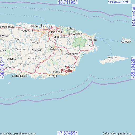
Playita GPS coordinates[2]
18° 2' 40.884" North, 65° 54' 26.568" West
| Map corner | latitude | longitude |
|---|---|---|
| Upper-left | 18.71195°, | -66.61051° |
| Center: | 18.04469°, | -65.90738° |
| Lower-right: | 17.37489°, | -65.20426° |
| Map W x H: | 148.7×148.7 km | = 92.4×92.4mi |
| max Lat: | 18.50078° ⇑78.7% North |
| Playita: | 18.04469° |
| min Lat: | ⇓21.3% South 17.95358° |
| min Long | Playita | max Long |
| -67.2499° | -65.90738° | -65.30099° |
| W 80.9%⇐ | ⇒19.1% E |
Elevation
Elevation of Playita is 28 m = 92 ft, and this is 72.5 m = 238 ft below average elevation for this country.
| Max E: |
655 m = 2149 ft | 62.7% |
| Avg. | 100.5 m = 330 ft | |
| Playita | 28 m = 92 ft | |
Min E: |
1 m = 3 ft | 37.3% |
See also: Puerto Rico elevation on elevation.city.
Geographical zone
Playita is located in North Torrid zone (between Equator and Tropic of Cancer). Distance of this Northern Tropic circle is 599.5 km =372.5 mi to North.| Distance of | km | miles | from Playita |
|---|---|---|---|
| North Pole | 8000.7 | 4971.4 | to North |
| Arctic Circle | 5394.8 | 3352.2 | to North |
| Tropic Cancer | 599.5 | 372.5 | to North |
| Equator | 2006.4 | 1246.7 | to South |


Nearby cities:
15 places around Playita: (largest is in red/bold)
• Candelero Arriba
9.8 km =6.1 mi,  49°
49°
• Comunas
8.2 km =5.1 mi, 54°
• El Negro
6 km =3.7 mi,  97°
97°
• Emajagua
5.6 km =3.5 mi,  151°
151°
• Humacao
14.4 km =8.9 mi,  35°
35°
• La Fermina
15.6 km =9.7 mi,  21°
21°
• Lamboglia
10.9 km =6.8 mi,  229°
229°
• Las Piedras
16 km =9.9 mi, 15°
• Martorell
3.6 km =2.2 mi, 15°
• Maunabo
4.3 km =2.7 mi,  168°
168°
• Palmas
14 km =8.7 mi,  242°
242°
• Palo Seco
5.2 km =3.2 mi,  216°
216°
• Patillas
12.2 km =7.6 mi,  249°
249°
• Rosa Sanchez
2 km =1.2 mi,  341°
341°
• Yabucoa
3 km =1.9 mi,  77°
77°
Sources, notices
• [Note1] Compared only with cities in Puerto Rico existing in our database
• [Src1] Map data: © OpenStreetMap contributors (CC-BY-SA)
• [Src2] Other city data from geonames.org with taken over terms of usage.
• [Src3] Geographical zone / Annual Mean Temperature by Robert A. Rohde @ Wikipedia
