Cayey geodata
Cayey is a seat of a first-order administrative division; located in Puerto Rico in America/Puerto_Rico (GMT-4) time zone. With population of 18,494 people, there are 17 cities with bigger population in this country. Compared to other cities in Puerto Rico, 66.7% of cities are located further ↑North; 65.8% of cities are located further ←West and 92.4% of cities have lower elevation than Cayey. Note1


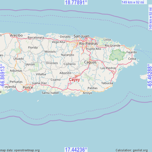
Cayey GPS coordinates[2]
18° 6' 42.876" North, 66° 9' 57.6" West
| Map corner | latitude | longitude |
|---|---|---|
| Upper-left | 18.77891°, | -66.86913° |
| Center: | 18.11191°, | -66.166° |
| Lower-right: | 17.44236°, | -65.46288° |
| Map W x H: | 148.6×148.6 km | = 92.3×92.3mi |
| max Lat: | 18.50078° ⇑66.7% North |
| Cayey: | 18.11191° |
| min Lat: | ⇓33.3% South 17.95358° |
| min Long | Cayey | max Long |
| -67.2499° | -66.166° | -65.30099° |
| W 65.8%⇐ | ⇒34.2% E |
Elevation
Elevation of Cayey is 397 m = 1302 ft, and this is 296.5 m = 973 ft above average elevation for this country.
| Max E: |
655 m = 2149 ft | 7.6% |
| Cayey | 397 m 1302 ft | |
| Avg. | 100.5 m = 330 ft | |
Min E: |
1 m = 3 ft | 92.4% |
See also: Puerto Rico elevation on elevation.city.
Geographical zone
Cayey is located in North Torrid zone (between Equator and Tropic of Cancer). Distance of this Northern Tropic circle is 592.1 km =367.9 mi to North.| Distance of | km | miles | from Cayey |
|---|---|---|---|
| North Pole | 7993.2 | 4966.7 | to North |
| Arctic Circle | 5387.3 | 3347.5 | to North |
| Tropic Cancer | 592.1 | 367.9 | to North |
| Equator | 2013.9 | 1251.4 | to South |


Nearby cities:
15 places around Cayey: (largest is in red/bold)
• Aibonito
11 km =6.8 mi,  286°
286°
• Bayamon
9.2 km =5.7 mi,  37°
37°
• Cidra
7.1 km =4.4 mi,  4°
4°
• Comerío
13.4 km =8.3 mi,  331°
331°
• G. L. Garcia
6.8 km =4.2 mi,  75°
75°
• Guayama
15.2 km =9.4 mi,  158°
158°
• La Plena
8.3 km =5.2 mi,  209°
209°
• Olimpo
13.7 km =8.5 mi,  153°
153°
• Parcelas La Milagrosa
7 km =4.3 mi,  340°
340°
• Parcelas Nuevas
3.2 km =2 mi,  347°
347°
• Pastos
9.8 km =6.1 mi,  273°
273°
• Santa Clara
12.5 km =7.8 mi,  18°
18°
• Sumidero
12.5 km =7.8 mi, 18°
• Vázquez
9.2 km =5.7 mi,  236°
236°
• Yaurel
14.9 km =9.3 mi,  129°
129°
Sources, notices
• [Note1] Compared only with cities in Puerto Rico existing in our database
• [Src1] Map data: © OpenStreetMap contributors (CC-BY-SA)
• [Src2] Other city data from geonames.org with taken over terms of usage.
• [Src3] Geographical zone / Annual Mean Temperature by Robert A. Rohde @ Wikipedia
