Vázquez geodata
Vázquez (Salinas) is a populated place; located in Puerto Rico in America/Puerto_Rico (GMT-4) time zone. With population of 2,297 people, there are 126 cities with bigger population in this country. Compared to other cities in Puerto Rico, 72.9% of cities are located further ↑North; 59.1% of cities are located further ←West and 80.4% of cities have lower elevation than Vázquez. Note1


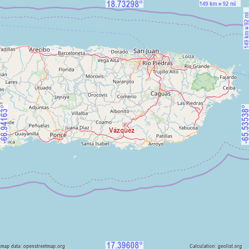
Vázquez GPS coordinates[2]
18° 3' 56.88" North, 66° 14' 18.6" West
| Map corner | latitude | longitude |
|---|---|---|
| Upper-left | 18.73298°, | -66.94163° |
| Center: | 18.0658°, | -66.2385° |
| Lower-right: | 17.39608°, | -65.53538° |
| Map W x H: | 148.6×148.7 km | = 92.3×92.4mi |
| max Lat: | 18.50078° ⇑72.9% North |
| Vázquez: | 18.0658° |
| min Lat: | ⇓27.1% South 17.95358° |
| min Long | Vázquez | max Long |
| -67.2499° | -66.2385° | -65.30099° |
| W 59.1%⇐ | ⇒40.9% E |
Elevation
Elevation of Vázquez is 157 m = 515 ft, and this is 56.5 m = 185 ft above average elevation for this country.
| Max E: |
655 m = 2149 ft | 19.6% |
| Vázquez | 157 m 515 ft | |
| Avg. | 100.5 m = 330 ft | |
Min E: |
1 m = 3 ft | 80.4% |
See also: Puerto Rico elevation on elevation.city.
Geographical zone
Vázquez is located in North Torrid zone (between Equator and Tropic of Cancer). Distance of this Northern Tropic circle is 597.2 km =371.1 mi to North.| Distance of | km | miles | from Vázquez |
|---|---|---|---|
| North Pole | 7998.3 | 4969.9 | to North |
| Arctic Circle | 5392.4 | 3350.7 | to North |
| Tropic Cancer | 597.2 | 371.1 | to North |
| Equator | 2008.7 | 1248.1 | to South |


Nearby cities:
15 places around Vázquez: (largest is in red/bold)
• Aibonito
8.7 km =5.4 mi,  340°
340°
• Cayey
9.2 km =5.7 mi,  56°
56°
• Central Aguirre
12.6 km =7.8 mi,  172°
172°
• Coamo
12.7 km =7.9 mi,  277°
277°
• Coco
6.9 km =4.3 mi,  198°
198°
• Coquí
10.3 km =6.4 mi, 173°
• La Plena
4.2 km =2.6 mi,  120°
120°
• Las Ochenta
12.3 km =7.6 mi,  222°
222°
• Mariano Colón
11 km =6.8 mi,  244°
244°
• Palmarejo
9.2 km =5.7 mi,  271°
271°
• Parcelas La Milagrosa
12.8 km =8 mi,  24°
24°
• Parcelas Nuevas
10.8 km =6.7 mi,  40°
40°
• Pastos
6.2 km =3.9 mi, 339°
• Playita
12.9 km =8 mi, 204°
• Salinas
11.7 km =7.3 mi,  212°
212°
Sources, notices
• [Note1] Compared only with cities in Puerto Rico existing in our database
• [Src1] Map data: © OpenStreetMap contributors (CC-BY-SA)
• [Src2] Other city data from geonames.org with taken over terms of usage.
• [Src3] Geographical zone / Annual Mean Temperature by Robert A. Rohde @ Wikipedia
