Pastos geodata
Pastos (Aibonito) is a populated place; located in Puerto Rico in America/Puerto_Rico (GMT-4) time zone. With population of 1,528 people, there are 170 cities with bigger population in this country. Compared to other cities in Puerto Rico, 66.2% of cities are located further ↑North; 56.4% of cities are located further ←West and 100% of cities have lower elevation than Pastos. Note1


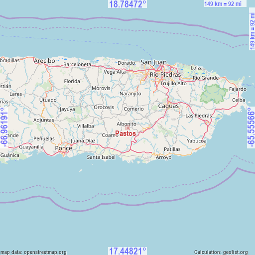
Pastos GPS coordinates[2]
18° 7' 3.864" North, 66° 15' 31.608" West
| Map corner | latitude | longitude |
|---|---|---|
| Upper-left | 18.78472°, | -66.96191° |
| Center: | 18.11774°, | -66.25878° |
| Lower-right: | 17.44821°, | -65.55566° |
| Map W x H: | 148.6×148.6 km | = 92.3×92.3mi |
| max Lat: | 18.50078° ⇑66.2% North |
| Pastos: | 18.11774° |
| min Lat: | ⇓33.8% South 17.95358° |
| min Long | Pastos | max Long |
| -67.2499° | -66.25878° | -65.30099° |
| W 56.4%⇐ | ⇒43.6% E |
Elevation
Elevation of Pastos is 655 m = 2149 ft, and this is 554.5 m = 1819 ft above average elevation for this country.
| Max E: |
655 m = 2149 ft | 0% |
| Pastos | 655 m 2149 ft | |
| Avg. | 100.5 m = 330 ft | |
Min E: |
1 m = 3 ft | 100% |
See also: Puerto Rico elevation on elevation.city.
Geographical zone
Pastos is located in North Torrid zone (between Equator and Tropic of Cancer). Distance of this Northern Tropic circle is 591.4 km =367.5 mi to North.| Distance of | km | miles | from Pastos |
|---|---|---|---|
| North Pole | 7992.6 | 4966.4 | to North |
| Arctic Circle | 5386.7 | 3347.1 | to North |
| Tropic Cancer | 591.4 | 367.5 | to North |
| Equator | 2014.5 | 1251.8 | to South |


Nearby cities:
15 places around Pastos: (largest is in red/bold)
• Aibonito
2.6 km =1.6 mi,  342°
342°
• Barranquitas
9.2 km =5.7 mi,  326°
326°
• Cayey
9.8 km =6.1 mi,  93°
93°
• Cidra
12.2 km =7.6 mi,  57°
57°
• Coamo
11.3 km =7 mi,  248°
248°
• Coco
12.3 km =7.6 mi,  180°
180°
• Comerío
11.7 km =7.3 mi,  17°
17°
• La Plena
9.8 km =6.1 mi,  144°
144°
• Mariano Colón
13.1 km =8.1 mi,  216°
216°
• Palmarejo
9 km =5.6 mi,  231°
231°
• Palomas
12.8 km =8 mi,  1°
1°
• Parcelas La Milagrosa
9.5 km =5.9 mi,  51°
51°
• Parcelas Nuevas
9.5 km =5.9 mi,  74°
74°
• Parcelas Peñuelas
15.8 km =9.8 mi,  213°
213°
• Vázquez
6.2 km =3.9 mi,  159°
159°
Sources, notices
• [Note1] Compared only with cities in Puerto Rico existing in our database
• [Src1] Map data: © OpenStreetMap contributors (CC-BY-SA)
• [Src2] Other city data from geonames.org with taken over terms of usage.
• [Src3] Geographical zone / Annual Mean Temperature by Robert A. Rohde @ Wikipedia
