Santa Clara geodata
Santa Clara (Aguas Buenas) is a populated place; located in Puerto Rico in America/Puerto_Rico (GMT-4) time zone. With population of 1,138 people, there are 207 cities with bigger population in this country. Compared to other cities in Puerto Rico, 54.2% of cities are located further ↑North; 67.6% of cities are located further ←West and 96.4% of cities have lower elevation than Santa Clara. Note1


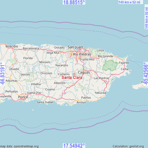
Santa Clara GPS coordinates[2]
18° 13' 6.852" North, 66° 7' 43.608" West
| Map corner | latitude | longitude |
|---|---|---|
| Upper-left | 18.88515°, | -66.83191° |
| Center: | 18.21857°, | -66.12878° |
| Lower-right: | 17.54942°, | -65.42566° |
| Map W x H: | 148.5×148.5 km | = 92.3×92.3mi |
| max Lat: | 18.50078° ⇑54.2% North |
| Santa Clara: | 18.21857° |
| min Lat: | ⇓45.8% South 17.95358° |
| min Long | Santa Clara | max Long |
| -67.2499° | -66.12878° | -65.30099° |
| W 67.6%⇐ | ⇒32.4% E |
Elevation
Elevation of Santa Clara is 450 m = 1476 ft, and this is 349.5 m = 1147 ft above average elevation for this country.
| Max E: |
655 m = 2149 ft | 3.6% |
| Santa Clara | 450 m 1476 ft | |
| Avg. | 100.5 m = 330 ft | |
Min E: |
1 m = 3 ft | 96.4% |
See also: Puerto Rico elevation on elevation.city.
Geographical zone
Santa Clara is located in North Torrid zone (between Equator and Tropic of Cancer). Distance of this Northern Tropic circle is 580.2 km =360.5 mi to North.| Distance of | km | miles | from Santa Clara |
|---|---|---|---|
| North Pole | 7981.3 | 4959.3 | to North |
| Arctic Circle | 5375.5 | 3340.2 | to North |
| Tropic Cancer | 580.2 | 360.5 | to North |
| Equator | 2025.7 | 1258.7 | to South |


Nearby cities:
15 places around Santa Clara: (largest is in red/bold)
• Aguas Buenas
5.1 km =3.2 mi,  32°
32°
• Bairoa
10.4 km =6.5 mi,  64°
64°
• Bayamon
4.8 km =3 mi,  160°
160°
• Caguas
8.7 km =5.4 mi,  78°
78°
• Cayey
12.5 km =7.8 mi,  198°
198°
• Cidra
5.9 km =3.7 mi,  215°
215°
• Comerío
10.3 km =6.4 mi,  269°
269°
• G. L. Garcia
10.5 km =6.5 mi,  165°
165°
• Guaynabo
15.6 km =9.7 mi,  6°
6°
• Jagual
15.4 km =9.6 mi,  114°
114°
• Naranjito
15.3 km =9.5 mi,  306°
306°
• Palomas
13.6 km =8.5 mi,  276°
276°
• Parcelas La Milagrosa
8.2 km =5.1 mi,  229°
229°
• Parcelas Nuevas
9.9 km =6.2 mi,  207°
207°
• Sumidero
0 km =0 mi,  0°
0°
Sources, notices
• [Note1] Compared only with cities in Puerto Rico existing in our database
• [Src1] Map data: © OpenStreetMap contributors (CC-BY-SA)
• [Src2] Other city data from geonames.org with taken over terms of usage.
• [Src3] Geographical zone / Annual Mean Temperature by Robert A. Rohde @ Wikipedia
