Pero Pinheiro geodata
Pero Pinheiro (Lisbon) is a populated place; located in Portugal in Europe/Lisbon (GMT+1) time zone. With population of 4,792 people, there are 446 cities with bigger population in this country. Compared to other cities in Portugal, 67% of cities are located further ↑North; 86.9% of cities are located further →East and 60.6% of cities have lower elevation than Pero Pinheiro. Note1


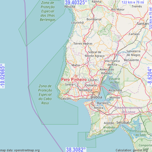
Pero Pinheiro GPS coordinates[2]
38° 51' 28.188" North, 9° 19' 24.672" West
| Map corner | latitude | longitude |
|---|---|---|
| Upper-left | 39.40325°, | -10.02665° |
| Center: | 38.85783°, | -9.32352° |
| Lower-right: | 38.3082°, | -8.6204° |
| Map W x H: | 121.8×121.8 km | = 75.7×75.7mi |
| max Lat: | 42.11337° ⇑67% North |
| Pero Pinheiro: | 38.85783° |
| min Lat: | ⇓33% South 32.6448° |
| min Long | Pero Pinheiro | max Long |
| -31.17847° | -9.32352° | -6.27308° |
| W 13.1%⇐ | ⇒86.9% E |
Elevation
Elevation of Pero Pinheiro is 158 m = 518 ft, and this is 19 m = 62 ft below average elevation for this country.
| Max E: |
1008 m = 3307 ft | 39.4% |
| Avg. | 177 m = 581 ft | |
| Pero Pinheiro | 158 m = 518 ft | |
Min E: |
-128 m = -420 ft | 60.6% |
See also: Portugal elevation on elevation.city.
Geographical zone
Pero Pinheiro is located in North temperate zone (between Tropic of Cancer and the Arctic Circle). Distance of this Northern Tropic circle is 1714.7 km =1065.5 mi to South.| Distance of | km | miles | from Pero Pinheiro |
|---|---|---|---|
| North Pole | 5686.5 | 3533.4 | to North |
| Arctic Circle | 3080.6 | 1914.2 | to North |
| Tropic Cancer | 1714.7 | 1065.5 | to South |
| Equator | 4320.6 | 2684.7 | to South |


Nearby cities:
15 places around Pero Pinheiro: (largest is in red/bold)
• Algueirão
6.9 km =4.3 mi,  194°
194°
• Almargem
4.6 km =2.9 mi,  108°
108°
• Azenhas do Mar
11.8 km =7.3 mi,  260°
260°
• Belas
10.4 km =6.5 mi,  150°
150°
• Cacém
10.3 km =6.4 mi,  167°
167°
• Caneças
9.7 km =6 mi,  120°
120°
• Fontanelas
10.1 km =6.3 mi, 263°
• Mafra
8.9 km =5.5 mi,  357°
357°
• Malveira
10 km =6.2 mi,  34°
34°
• Massamá
12.2 km =7.6 mi,  162°
162°
• Mem Martins
7.2 km =4.5 mi, 193°
• Rio de Mouro
10.2 km =6.3 mi,  182°
182°
• Sintra
7.9 km =4.9 mi,  216°
216°
• São João das Lampas
6.7 km =4.2 mi,  285°
285°
• Venda do Pinheiro
10.8 km =6.7 mi,  47°
47°
Sources, notices
• [Note1] Compared only with cities in Portugal existing in our database
• [Src1] Map data: © OpenStreetMap contributors (CC-BY-SA)
• [Src2] Other city data from geonames.org with taken over terms of usage.
• [Src3] Geographical zone / Annual Mean Temperature by Robert A. Rohde @ Wikipedia
