Quinta do Anjo geodata
Quinta do Anjo (District of Setúbal) is a populated place; located in Portugal in Europe/Lisbon (GMT+1) time zone. With population of 9,124 people, there are 242 cities with bigger population in this country. Compared to other cities in Portugal, 79.8% of cities are located further ↑North; 72.2% of cities are located further →East and 54.5% of cities have higher elevation than Quinta do Anjo. Note1


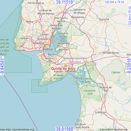
Quinta do Anjo GPS coordinates[2]
38° 34' 3.108" North, 8° 56' 32.208" West
| Map corner | latitude | longitude |
|---|---|---|
| Upper-left | 39.11518°, | -9.64541° |
| Center: | 38.56753°, | -8.94228° |
| Lower-right: | 38.01568°, | -8.23916° |
| Map W x H: | 122.3×122.3 km | = 76×76mi |
| max Lat: | 42.11337° ⇑79.8% North |
| Quinta do Anjo: | 38.56753° |
| min Lat: | ⇓20.2% South 32.6448° |
| min Long | Quinta do Anjo | max Long |
| -31.17847° | -8.94228° | -6.27308° |
| W 27.8%⇐ | ⇒72.2% E |
Elevation
Elevation of Quinta do Anjo is 94 m = 308 ft, and this is 83 m = 272 ft below average elevation for this country.
| Max E: |
1008 m = 3307 ft | 54.5% |
| Avg. | 177 m = 581 ft | |
| Quinta do Anjo | 94 m = 308 ft | |
Min E: |
-128 m = -420 ft | 45.5% |
See also: Portugal elevation on elevation.city.
Geographical zone
Quinta do Anjo is located in North temperate zone (between Tropic of Cancer and the Arctic Circle). Distance of this Northern Tropic circle is 1682.4 km =1045.4 mi to South.| Distance of | km | miles | from Quinta do Anjo |
|---|---|---|---|
| North Pole | 5718.8 | 3553.5 | to North |
| Arctic Circle | 3112.9 | 1934.3 | to North |
| Tropic Cancer | 1682.4 | 1045.4 | to South |
| Equator | 4288.3 | 2664.6 | to South |


Nearby cities:
15 places around Quinta do Anjo: (largest is in red/bold)
• Aldeia de Paio Pires
13.4 km =8.3 mi,  294°
294°
• Alhos Vedros
12 km =7.5 mi,  323°
323°
• Arrentela
15.2 km =9.4 mi, 294°
• Azeitão
8.2 km =5.1 mi,  229°
229°
• Barreiro
15.5 km =9.6 mi,  313°
313°
• Lavradio
14.7 km =9.1 mi, 319°
• Moita
10.2 km =6.3 mi,  335°
335°
• Montijo
15.7 km =9.8 mi,  349°
349°
• Palmela
3.6 km =2.2 mi,  87°
87°
• Pinhal Novo
7.5 km =4.7 mi,  19°
19°
• Quinta Do Conde
8.8 km =5.5 mi,  268°
268°
• Rosairinho
13.5 km =8.4 mi,  334°
334°
• Santo António da Charneca
10 km =6.2 mi, 310°
• Sarilhos Pequenos
13.2 km =8.2 mi, 344°
• Setúbal
6.7 km =4.2 mi,  135°
135°
Sources, notices
• [Note1] Compared only with cities in Portugal existing in our database
• [Src1] Map data: © OpenStreetMap contributors (CC-BY-SA)
• [Src2] Other city data from geonames.org with taken over terms of usage.
• [Src3] Geographical zone / Annual Mean Temperature by Robert A. Rohde @ Wikipedia
