Setúbal geodata
Setúbal (District of Setúbal) is a seat of a first-order administrative division; located in Portugal in Europe/Lisbon (GMT+1) time zone. With population of 117,110 people, there are 4 cities with bigger population in this country. Compared to other cities in Portugal, 80.8% of cities are located further ↑North; 71% of cities are located further →East and 90.3% of cities have higher elevation than Setúbal. Note1
Administrative division(s):
- Level 1: District of Setúbal
- Level 2: Setúbal
- Level 3: Setúbal (Santa Maria da Graça)


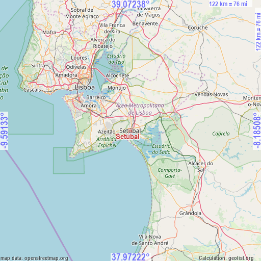
Setúbal GPS coordinates[2]
38° 31' 27.84" North, 8° 53' 17.52" West
| Map corner | latitude | longitude |
|---|---|---|
| Upper-left | 39.07238°, | -9.59133° |
| Center: | 38.5244°, | -8.8882° |
| Lower-right: | 37.97222°, | -8.18508° |
| Map W x H: | 122.3×122.3 km | = 76×76mi |
| max Lat: | 42.11337° ⇑80.8% North |
| Setúbal: | 38.5244° |
| min Lat: | ⇓19.2% South 32.6448° |
| min Long | Setúbal | max Long |
| -31.17847° | -8.8882° | -6.27308° |
| W 29%⇐ | ⇒71% E |
Elevation
Elevation of Setúbal is 16 m = 52 ft, and this is 161 m = 528 ft below average elevation for this country.
| Max E: |
1008 m = 3307 ft | 90.3% |
| Avg. | 177 m = 581 ft | |
| Setúbal | 16 m = 52 ft | |
Min E: |
-128 m = -420 ft | 9.7% |
See also: Setúbal elevation on elevation.city.
Geographical zone
Setúbal is located in North temperate zone (between Tropic of Cancer and the Arctic Circle). Distance of this Northern Tropic circle is 1677.6 km =1042.4 mi to South.| Distance of | km | miles | from Setúbal |
|---|---|---|---|
| North Pole | 5723.6 | 3556.5 | to North |
| Arctic Circle | 3117.7 | 1937.2 | to North |
| Tropic Cancer | 1677.6 | 1042.4 | to South |
| Equator | 4283.5 | 2661.6 | to South |


Nearby cities:
15 places around Setúbal: (largest is in red/bold)
• Aldeia de Paio Pires
19.8 km =12.3 mi,  301°
301°
• Alhos Vedros
18.7 km =11.6 mi,  320°
320°
• Azeitão
11 km =6.8 mi,  266°
266°
• Comporta
18.3 km =11.4 mi,  150°
150°
• Lavradio
21.4 km =13.3 mi, 318°
• Moita
16.6 km =10.3 mi,  327°
327°
• Montijo
21.6 km =13.4 mi,  339°
339°
• Palmela
5.1 km =3.2 mi,  347°
347°
• Pinhal Novo
12.1 km =7.5 mi, 349°
• Quinta Do Conde
14.2 km =8.8 mi,  288°
288°
• Quinta do Anjo
6.7 km =4.2 mi, 315°
• Rosairinho
20 km =12.4 mi, 328°
• Santo António da Charneca
16.7 km =10.4 mi,  312°
312°
• Sarilhos Pequenos
19.3 km =12 mi, 334°
• Sesimbra
20.6 km =12.8 mi,  244°
244°
Sources, notices
• [Note1] Compared only with cities in Portugal existing in our database
• [Src1] Map data: © OpenStreetMap contributors (CC-BY-SA)
• [Src2] Other city data from geonames.org with taken over terms of usage.
• [Src3] Geographical zone / Annual Mean Temperature by Robert A. Rohde @ Wikipedia
