Quarteira geodata
Quarteira (Faro) is a populated place; located in Portugal in Europe/Lisbon (GMT+1) time zone. With population of 18,783 people, there are 110 cities with bigger population in this country. Compared to other cities in Portugal, 95.5% of cities are located further ↑North; 76.6% of cities are located further ←West and 85.5% of cities have higher elevation than Quarteira. Note1


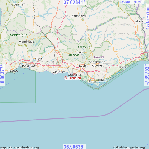
Quarteira GPS coordinates[2]
37° 4' 10.056" North, 8° 6' 2.304" West
| Map corner | latitude | longitude |
|---|---|---|
| Upper-left | 37.62841°, | -8.80377° |
| Center: | 37.06946°, | -8.10064° |
| Lower-right: | 36.50636°, | -7.39752° |
| Map W x H: | 124.8×124.8 km | = 77.5×77.5mi |
| max Lat: | 42.11337° ⇑95.5% North |
| Quarteira: | 37.06946° |
| min Lat: | ⇓4.5% South 32.6448° |
| min Long | Quarteira | max Long |
| -31.17847° | -8.10064° | -6.27308° |
| W 76.6%⇐ | ⇒23.4% E |
Elevation
Elevation of Quarteira is 23 m = 75 ft, and this is 154 m = 505 ft below average elevation for this country.
| Max E: |
1008 m = 3307 ft | 85.5% |
| Avg. | 177 m = 581 ft | |
| Quarteira | 23 m = 75 ft | |
Min E: |
-128 m = -420 ft | 14.5% |
See also: Portugal elevation on elevation.city.
Geographical zone
Quarteira is located in North temperate zone (between Tropic of Cancer and the Arctic Circle). Distance of this Northern Tropic circle is 1515.8 km =941.9 mi to South.| Distance of | km | miles | from Quarteira |
|---|---|---|---|
| North Pole | 5885.3 | 3657 | to North |
| Arctic Circle | 3279.4 | 2037.7 | to North |
| Tropic Cancer | 1515.8 | 941.9 | to South |
| Equator | 4121.7 | 2561.1 | to South |


Nearby cities:
15 places around Quarteira: (largest is in red/bold)
• Albufeira
13.4 km =8.3 mi,  278°
278°
• Algoz
20.8 km =12.9 mi,  300°
300°
• Almancil
6.5 km =4 mi,  72°
72°
• Boliqueime
9.1 km =5.7 mi,  325°
325°
• Estói
18.5 km =11.5 mi,  81°
81°
• Faro
16.4 km =10.2 mi,  110°
110°
• Ferreiras
13.8 km =8.6 mi, 298°
• Guia
18.9 km =11.7 mi,  290°
290°
• Loulé
10.4 km =6.5 mi,  43°
43°
• Olhos de Água
8.4 km =5.2 mi, 285°
• Paderne
15.1 km =9.4 mi,  323°
323°
• Santa Bárbara de Nexe
12.6 km =7.8 mi, 71°
• São Brás de Alportel
21.1 km =13.1 mi,  63°
63°
• Tunes
17.7 km =11 mi,  307°
307°
• Vilamoura
2.5 km =1.6 mi, 323°
Sources, notices
• [Note1] Compared only with cities in Portugal existing in our database
• [Src1] Map data: © OpenStreetMap contributors (CC-BY-SA)
• [Src2] Other city data from geonames.org with taken over terms of usage.
• [Src3] Geographical zone / Annual Mean Temperature by Robert A. Rohde @ Wikipedia
