Faro geodata
Faro is a seat of a first-order administrative division; located in Portugal in Europe/Lisbon (GMT+0) time zone. With population of 41,355 people, there are 26 cities with bigger population in this country. Compared to other cities in Portugal, 95.9% of cities are located further ↑North; 81.2% of cities are located further ←West and 93.2% of cities have higher elevation than Faro. Note1


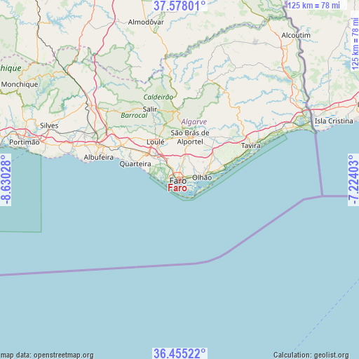
Faro GPS coordinates[2]
37° 1' 7.284" North, 7° 55' 37.776" West
| Map corner | latitude | longitude |
|---|---|---|
| Upper-left | 37.57801°, | -8.63028° |
| Center: | 37.01869°, | -7.92716° |
| Lower-right: | 36.45522°, | -7.22403° |
| Map W x H: | 124.8×124.8 km | = 77.5×77.5mi |
| max Lat: | 42.11337° ⇑95.9% North |
| Faro: | 37.01869° |
| min Lat: | ⇓4.1% South 32.6448° |
| min Long | Faro | max Long |
| -31.17847° | -7.92716° | -6.27308° |
| W 81.2%⇐ | ⇒18.8% E |
Elevation
Elevation of Faro is 12 m = 39 ft, and this is 165 m = 541 ft below average elevation for this country.
| Max E: |
1008 m = 3307 ft | 93.2% |
| Avg. | 177 m = 581 ft | |
| Faro | 12 m = 39 ft | |
Min E: |
-128 m = -420 ft | 6.8% |
See also: Faro elevation on elevation.city.
Geographical zone
Faro is located in North temperate zone (between Tropic of Cancer and the Arctic Circle). Distance of this Northern Tropic circle is 1510.2 km =938.4 mi to South.| Distance of | km | miles | from Faro |
|---|---|---|---|
| North Pole | 5891 | 3660.5 | to North |
| Arctic Circle | 3285.1 | 2041.3 | to North |
| Tropic Cancer | 1510.2 | 938.4 | to South |
| Equator | 4116.1 | 2557.6 | to South |


Nearby cities:
15 places around Faro: (largest is in red/bold)
• Almancil
11.9 km =7.4 mi,  309°
309°
• Boliqueime
24.4 km =15.2 mi,  302°
302°
• Estói
9 km =5.6 mi,  18°
18°
• Fuzeta
16.5 km =10.3 mi,  76°
76°
• Laranjeiro
11.9 km =7.4 mi,  62°
62°
• Loulé
15.6 km =9.7 mi,  328°
328°
• Luz
21.4 km =13.3 mi,  67°
67°
• Moncarapacho
14.3 km =8.9 mi, 59°
• Olhos de Água
24.8 km =15.4 mi,  288°
288°
• Olhão
7.7 km =4.8 mi, 81°
• Quarteira
16.4 km =10.2 mi, 290°
• Santa Bárbara de Nexe
10.3 km =6.4 mi,  340°
340°
• Santa Luzia
25.3 km =15.7 mi, 68°
• São Brás de Alportel
15.4 km =9.6 mi,  13°
13°
• Vilamoura
18.5 km =11.5 mi, 294°
Sources, notices
• [Note1] Compared only with cities in Portugal existing in our database
• [Src1] Map data: © OpenStreetMap contributors (CC-BY-SA)
• [Src2] Other city data from geonames.org with taken over terms of usage.
• [Src3] Geographical zone / Annual Mean Temperature by Robert A. Rohde @ Wikipedia
