Vilamoura geodata
Vilamoura (Faro) is a populated place; located in Portugal in Europe/Lisbon (GMT+1) time zone. With population of 1,900 people, there are 660 cities with bigger population in this country. Compared to other cities in Portugal, 95% of cities are located further ↑North; 76.1% of cities are located further ←West and 90.3% of cities have higher elevation than Vilamoura. Note1


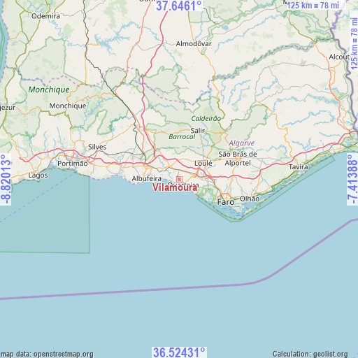
Vilamoura GPS coordinates[2]
37° 5' 14.208" North, 8° 7' 1.236" West
| Map corner | latitude | longitude |
|---|---|---|
| Upper-left | 37.6461°, | -8.82013° |
| Center: | 37.08728°, | -8.11701° |
| Lower-right: | 36.52431°, | -7.41388° |
| Map W x H: | 124.7×124.7 km | = 77.5×77.5mi |
| max Lat: | 42.11337° ⇑95% North |
| Vilamoura: | 37.08728° |
| min Lat: | ⇓5% South 32.6448° |
| min Long | Vilamoura | max Long |
| -31.17847° | -8.11701° | -6.27308° |
| W 76.1%⇐ | ⇒23.9% E |
Elevation
Elevation of Vilamoura is 16 m = 52 ft, and this is 161 m = 528 ft below average elevation for this country.
| Max E: |
1008 m = 3307 ft | 90.3% |
| Avg. | 177 m = 581 ft | |
| Vilamoura | 16 m = 52 ft | |
Min E: |
-128 m = -420 ft | 9.7% |
See also: Portugal elevation on elevation.city.
Geographical zone
Vilamoura is located in North temperate zone (between Tropic of Cancer and the Arctic Circle). Distance of this Northern Tropic circle is 1517.8 km =943.1 mi to South.| Distance of | km | miles | from Vilamoura |
|---|---|---|---|
| North Pole | 5883.3 | 3655.7 | to North |
| Arctic Circle | 3277.5 | 2036.5 | to North |
| Tropic Cancer | 1517.8 | 943.1 | to South |
| Equator | 4123.7 | 2562.3 | to South |


Nearby cities:
15 places around Vilamoura: (largest is in red/bold)
• Albufeira
11.8 km =7.3 mi,  270°
270°
• Algoz
18.6 km =11.6 mi,  296°
296°
• Almancil
7.7 km =4.8 mi,  90°
90°
• Boliqueime
6.6 km =4.1 mi,  326°
326°
• Estói
19.8 km =12.3 mi, 87°
• Faro
18.5 km =11.5 mi,  114°
114°
• Ferreiras
11.7 km =7.3 mi,  293°
293°
• Guia
16.9 km =10.5 mi, 286°
• Loulé
10.3 km =6.4 mi,  56°
56°
• Olhos de Água
6.6 km =4.1 mi, 272°
• Paderne
12.7 km =7.9 mi,  323°
323°
• Pêra
20.3 km =12.6 mi,  281°
281°
• Quarteira
2.5 km =1.6 mi,  143°
143°
• Santa Bárbara de Nexe
13.5 km =8.4 mi,  81°
81°
• Tunes
15.3 km =9.5 mi, 304°
Sources, notices
• [Note1] Compared only with cities in Portugal existing in our database
• [Src1] Map data: © OpenStreetMap contributors (CC-BY-SA)
• [Src2] Other city data from geonames.org with taken over terms of usage.
• [Src3] Geographical zone / Annual Mean Temperature by Robert A. Rohde @ Wikipedia
