Almancil geodata
Almancil (Faro) is a populated place; located in Portugal in Europe/Lisbon (GMT+1) time zone. With population of 9,898 people, there are 220 cities with bigger population in this country. Compared to other cities in Portugal, 95.1% of cities are located further ↑North; 78.2% of cities are located further ←West and 67.9% of cities have higher elevation than Almancil. Note1


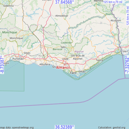
Almancil GPS coordinates[2]
37° 5' 12.696" North, 8° 1' 50.664" West
| Map corner | latitude | longitude |
|---|---|---|
| Upper-left | 37.64568°, | -8.73387° |
| Center: | 37.08686°, | -8.03074° |
| Lower-right: | 36.52389°, | -7.32762° |
| Map W x H: | 124.7×124.7 km | = 77.5×77.5mi |
| max Lat: | 42.11337° ⇑95.1% North |
| Almancil: | 37.08686° |
| min Lat: | ⇓4.9% South 32.6448° |
| min Long | Almancil | max Long |
| -31.17847° | -8.03074° | -6.27308° |
| W 78.2%⇐ | ⇒21.8% E |
Elevation
Elevation of Almancil is 55 m = 180 ft, and this is 122 m = 400 ft below average elevation for this country.
| Max E: |
1008 m = 3307 ft | 67.9% |
| Avg. | 177 m = 581 ft | |
| Almancil | 55 m = 180 ft | |
Min E: |
-128 m = -420 ft | 32.1% |
See also: Portugal elevation on elevation.city.
Geographical zone
Almancil is located in North temperate zone (between Tropic of Cancer and the Arctic Circle). Distance of this Northern Tropic circle is 1517.8 km =943.1 mi to South.| Distance of | km | miles | from Almancil |
|---|---|---|---|
| North Pole | 5883.4 | 3655.8 | to North |
| Arctic Circle | 3277.5 | 2036.5 | to North |
| Tropic Cancer | 1517.8 | 943.1 | to South |
| Equator | 4123.7 | 2562.3 | to South |


Nearby cities:
15 places around Almancil: (largest is in red/bold)
• Albufeira
19.5 km =12.1 mi,  270°
270°
• Boliqueime
12.6 km =7.8 mi,  296°
296°
• Estói
12.1 km =7.5 mi,  85°
85°
• Faro
11.9 km =7.4 mi,  129°
129°
• Ferreiras
18.9 km =11.7 mi,  284°
284°
• Laranjeiro
19.9 km =12.4 mi,  96°
96°
• Loulé
5.7 km =3.5 mi,  9°
9°
• Moncarapacho
21.6 km =13.4 mi, 90°
• Olhos de Água
14.3 km =8.9 mi, 271°
• Olhão
18 km =11.2 mi,  111°
111°
• Paderne
18.3 km =11.4 mi, 304°
• Quarteira
6.5 km =4 mi,  252°
252°
• Santa Bárbara de Nexe
6.1 km =3.8 mi,  69°
69°
• São Brás de Alportel
14.7 km =9.1 mi,  59°
59°
• Vilamoura
7.7 km =4.8 mi, 270°
Sources, notices
• [Note1] Compared only with cities in Portugal existing in our database
• [Src1] Map data: © OpenStreetMap contributors (CC-BY-SA)
• [Src2] Other city data from geonames.org with taken over terms of usage.
• [Src3] Geographical zone / Annual Mean Temperature by Robert A. Rohde @ Wikipedia
