Loulé geodata
Loulé (Faro) is a seat of a second-order administrative division; located in Portugal in Europe/Lisbon (GMT+1) time zone. With population of 23,109 people, there are 80 cities with bigger population in this country. Compared to other cities in Portugal, 92.5% of cities are located further ↑North; 78.5% of cities are located further ←West and 67% of cities have lower elevation than Loulé. Note1


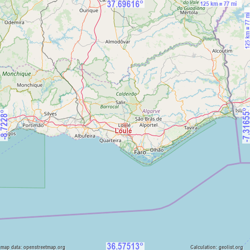
Loulé GPS coordinates[2]
37° 8' 15.792" North, 8° 1' 10.848" West
| Map corner | latitude | longitude |
|---|---|---|
| Upper-left | 37.69616°, | -8.7228° |
| Center: | 37.13772°, | -8.01968° |
| Lower-right: | 36.57513°, | -7.31655° |
| Map W x H: | 124.6×124.6 km | = 77.4×77.4mi |
| max Lat: | 42.11337° ⇑92.5% North |
| Loulé: | 37.13772° |
| min Lat: | ⇓7.5% South 32.6448° |
| min Long | Loulé | max Long |
| -31.17847° | -8.01968° | -6.27308° |
| W 78.5%⇐ | ⇒21.5% E |
Elevation
Elevation of Loulé is 186 m = 610 ft, and this is 9 m = 30 ft above average elevation for this country.
| Max E: |
1008 m = 3307 ft | 33% |
| Loulé | 186 m 610 ft | |
| Avg. | 177 m = 581 ft | |
Min E: |
-128 m = -420 ft | 67% |
See also: Portugal elevation on elevation.city.
Geographical zone
Loulé is located in North temperate zone (between Tropic of Cancer and the Arctic Circle). Distance of this Northern Tropic circle is 1523.4 km =946.6 mi to South.| Distance of | km | miles | from Loulé |
|---|---|---|---|
| North Pole | 5877.7 | 3652.2 | to North |
| Arctic Circle | 3271.8 | 2033 | to North |
| Tropic Cancer | 1523.4 | 946.6 | to South |
| Equator | 4129.3 | 2565.8 | to South |


Nearby cities:
15 places around Loulé: (largest is in red/bold)
• Albufeira
21.2 km =13.2 mi,  254°
254°
• Almancil
5.7 km =3.5 mi,  189°
189°
• Boliqueime
12.3 km =7.6 mi,  269°
269°
• Estói
12.1 km =7.5 mi,  113°
113°
• Faro
15.6 km =9.7 mi,  148°
148°
• Ferreiras
19.3 km =12 mi, 267°
• Laranjeiro
20.3 km =12.6 mi, 112°
• Moncarapacho
21.4 km =13.3 mi, 106°
• Olhos de Água
16.1 km =10 mi, 250°
• Olhão
20 km =12.4 mi,  127°
127°
• Paderne
16.8 km =10.4 mi,  286°
286°
• Quarteira
10.4 km =6.5 mi,  223°
223°
• Santa Bárbara de Nexe
5.9 km =3.7 mi, 126°
• São Brás de Alportel
11.8 km =7.3 mi,  81°
81°
• Vilamoura
10.3 km =6.4 mi,  236°
236°
Sources, notices
• [Note1] Compared only with cities in Portugal existing in our database
• [Src1] Map data: © OpenStreetMap contributors (CC-BY-SA)
• [Src2] Other city data from geonames.org with taken over terms of usage.
• [Src3] Geographical zone / Annual Mean Temperature by Robert A. Rohde @ Wikipedia
