Santarém geodata
Santarém is a seat of a first-order administrative division; located in Portugal in Europe/Lisbon (GMT+1) time zone. With population of 29,385 people, there are 51 cities with bigger population in this country. Compared to other cities in Portugal, 59.7% of cities are located further ↑North; 61.8% of cities are located further →East and 51.6% of cities have higher elevation than Santarém. Note1


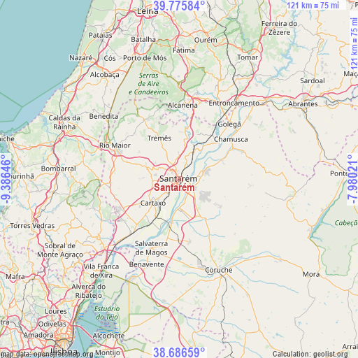
Santarém GPS coordinates[2]
39° 13' 59.988" North, 8° 40' 59.988" West
| Map corner | latitude | longitude |
|---|---|---|
| Upper-left | 39.77584°, | -9.38646° |
| Center: | 39.23333°, | -8.68333° |
| Lower-right: | 38.68659°, | -7.98021° |
| Map W x H: | 121.1×121.1 km | = 75.2×75.2mi |
| max Lat: | 42.11337° ⇑59.7% North |
| Santarém: | 39.23333° |
| min Lat: | ⇓40.3% South 32.6448° |
| min Long | Santarém | max Long |
| -31.17847° | -8.68333° | -6.27308° |
| W 38.2%⇐ | ⇒61.8% E |
Elevation
Elevation of Santarém is 107 m = 351 ft, and this is 70 m = 230 ft below average elevation for this country.
| Max E: |
1008 m = 3307 ft | 51.6% |
| Avg. | 177 m = 581 ft | |
| Santarém | 107 m = 351 ft | |
Min E: |
-128 m = -420 ft | 48.4% |
See also: Portugal elevation on elevation.city.
Geographical zone
Santarém is located in North temperate zone (between Tropic of Cancer and the Arctic Circle). Distance of this Northern Tropic circle is 1756.4 km =1091.4 mi to South.| Distance of | km | miles | from Santarém |
|---|---|---|---|
| North Pole | 5644.7 | 3507.5 | to North |
| Arctic Circle | 3038.8 | 1888.2 | to North |
| Tropic Cancer | 1756.4 | 1091.4 | to South |
| Equator | 4362.3 | 2710.6 | to South |


Nearby cities:
15 places around Santarém: (largest is in red/bold)
• Alcanede
23.5 km =14.6 mi,  329°
329°
• Alcanhões
7.3 km =4.5 mi,  17°
17°
• Almeirim
5.6 km =3.5 mi,  119°
119°
• Alpiarça
9.1 km =5.7 mi,  73°
73°
• Aveiras de Cima
21.4 km =13.3 mi,  240°
240°
• Azinhaga
18.4 km =11.4 mi,  45°
45°
• Bemfica
10 km =6.2 mi,  181°
181°
• Cartaxo
12.1 km =7.5 mi,  227°
227°
• Fazendas de Almeirim
11.7 km =7.3 mi, 123°
• Marinhais
20.7 km =12.9 mi, 184°
• Pontével
16.3 km =10.1 mi, 235°
• São Vicente do Paul
13.9 km =8.6 mi, 22°
• Vale de Figueira
9.3 km =5.8 mi,  30°
30°
• Vale de Santarém
6.1 km =3.8 mi,  218°
218°
• Vila Chã de Ourique
9.9 km =6.2 mi, 226°
Sources, notices
• [Note1] Compared only with cities in Portugal existing in our database
• [Src1] Map data: © OpenStreetMap contributors (CC-BY-SA)
• [Src2] Other city data from geonames.org with taken over terms of usage.
• [Src3] Geographical zone / Annual Mean Temperature by Robert A. Rohde @ Wikipedia
