Ponte de Sôr geodata
Ponte de Sôr (Portalegre) is a seat of a second-order administrative division; located in Portugal in Europe/Lisbon (GMT+1) time zone. With population of 11,062 people, there are 195 cities with bigger population in this country. Compared to other cities in Portugal, 59.2% of cities are located further ↑North; 78.6% of cities are located further ←West and 51.5% of cities have higher elevation than Ponte de Sôr. Note1


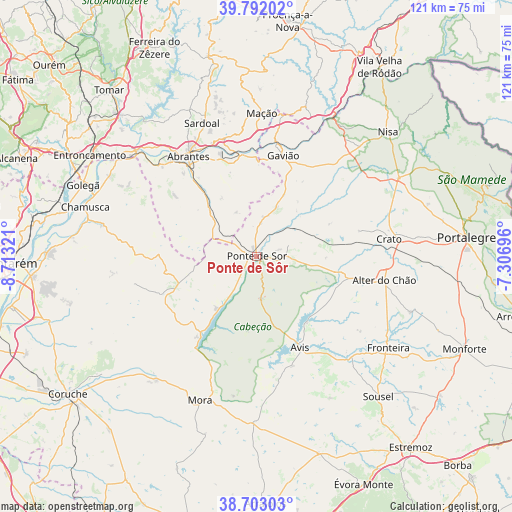
Ponte de Sôr GPS coordinates[2]
39° 14' 58.704" North, 8° 0' 36.324" West
| Map corner | latitude | longitude |
|---|---|---|
| Upper-left | 39.79202°, | -8.71321° |
| Center: | 39.24964°, | -8.01009° |
| Lower-right: | 38.70303°, | -7.30696° |
| Map W x H: | 121.1×121.1 km | = 75.2×75.2mi |
| max Lat: | 42.11337° ⇑59.2% North |
| Ponte de Sôr: | 39.24964° |
| min Lat: | ⇓40.8% South 32.6448° |
| min Long | Ponte de Sôr | max Long |
| -31.17847° | -8.01009° | -6.27308° |
| W 78.6%⇐ | ⇒21.4% E |
Elevation
Elevation of Ponte de Sôr is 108 m = 354 ft, and this is 69 m = 226 ft below average elevation for this country.
| Max E: |
1008 m = 3307 ft | 51.5% |
| Avg. | 177 m = 581 ft | |
| Ponte de Sôr | 108 m = 354 ft | |
Min E: |
-128 m = -420 ft | 48.5% |
See also: Portugal elevation on elevation.city.
Geographical zone
Ponte de Sôr is located in North temperate zone (between Tropic of Cancer and the Arctic Circle). Distance of this Northern Tropic circle is 1758.2 km =1092.5 mi to South.| Distance of | km | miles | from Ponte de Sôr |
|---|---|---|---|
| North Pole | 5642.9 | 3506.3 | to North |
| Arctic Circle | 3037 | 1887.1 | to North |
| Tropic Cancer | 1758.2 | 1092.5 | to South |
| Equator | 4364.2 | 2711.8 | to South |


Nearby cities:
15 places around Ponte de Sôr: (largest is in red/bold)
• Abrantes
29.1 km =18.1 mi,  325°
325°
• Alferrarede
29.3 km =18.2 mi, 332°
• Alter do Chão
30.8 km =19.1 mi,  100°
100°
• Atalaia
25.7 km =16 mi,  27°
27°
• Avis
24 km =14.9 mi,  154°
154°
• Comenda
25.8 km =16 mi,  49°
49°
• Gavião
24.8 km =15.4 mi,  15°
15°
• Gáfete
33.3 km =20.7 mi,  57°
57°
• Mação
34.1 km =21.2 mi,  2°
2°
• Montargil
23.6 km =14.7 mi,  215°
215°
• Pego
26.4 km =16.4 mi, 333°
• Santo André
29.6 km =18.4 mi, 223°
• São Miguel de Rio Torto
27.1 km =16.8 mi,  318°
318°
• Tramagal
30.4 km =18.9 mi, 317°
• Vale da Amoreira
33.5 km =20.8 mi,  126°
126°
Sources, notices
• [Note1] Compared only with cities in Portugal existing in our database
• [Src1] Map data: © OpenStreetMap contributors (CC-BY-SA)
• [Src2] Other city data from geonames.org with taken over terms of usage.
• [Src3] Geographical zone / Annual Mean Temperature by Robert A. Rohde @ Wikipedia
