Montargil geodata
Montargil (Portalegre) is a populated place; located in Portugal in Europe/Lisbon (GMT+1) time zone. With population of 2,316 people, there are 626 cities with bigger population in this country. Compared to other cities in Portugal, 62.6% of cities are located further ↑North; 74.1% of cities are located further ←West and 60.2% of cities have lower elevation than Montargil. Note1


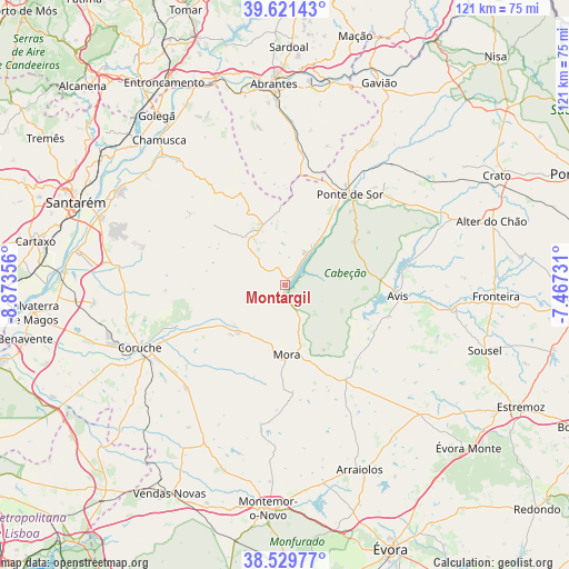
Montargil GPS coordinates[2]
39° 4' 39.756" North, 8° 10' 13.584" West
| Map corner | latitude | longitude |
|---|---|---|
| Upper-left | 39.62143°, | -8.87356° |
| Center: | 39.07771°, | -8.17044° |
| Lower-right: | 38.52977°, | -7.46731° |
| Map W x H: | 121.4×121.4 km | = 75.4×75.4mi |
| max Lat: | 42.11337° ⇑62.6% North |
| Montargil: | 39.07771° |
| min Lat: | ⇓37.4% South 32.6448° |
| min Long | Montargil | max Long |
| -31.17847° | -8.17044° | -6.27308° |
| W 74.1%⇐ | ⇒25.9% E |
Elevation
Elevation of Montargil is 155 m = 509 ft, and this is 22 m = 72 ft below average elevation for this country.
| Max E: |
1008 m = 3307 ft | 39.8% |
| Avg. | 177 m = 581 ft | |
| Montargil | 155 m = 509 ft | |
Min E: |
-128 m = -420 ft | 60.2% |
See also: Portugal elevation on elevation.city.
Geographical zone
Montargil is located in North temperate zone (between Tropic of Cancer and the Arctic Circle). Distance of this Northern Tropic circle is 1739.1 km =1080.6 mi to South.| Distance of | km | miles | from Montargil |
|---|---|---|---|
| North Pole | 5662 | 3518.2 | to North |
| Arctic Circle | 3056.1 | 1899 | to North |
| Tropic Cancer | 1739.1 | 1080.6 | to South |
| Equator | 4345 | 2699.9 | to South |


Nearby cities:
15 places around Montargil: (largest is in red/bold)
• Almeirim
41.9 km =26 mi,  290°
290°
• Alpiarça
40.7 km =25.3 mi,  299°
299°
• Arraiolos
42.5 km =26.4 mi,  157°
157°
• Avis
24.2 km =15 mi,  96°
96°
• Azinhaga
43.2 km =26.8 mi,  314°
314°
• Coruche
33.3 km =20.7 mi,  246°
246°
• Fazendas de Almeirim
36.1 km =22.4 mi, 287°
• Mora
14.9 km =9.3 mi,  177°
177°
• Pego
42.7 km =26.5 mi,  2°
2°
• Pinheiro Grande
41.7 km =25.9 mi,  326°
326°
• Ponte de Sôr
23.6 km =14.7 mi,  35°
35°
• Santo André
6.8 km =4.2 mi, 248°
• São Miguel de Rio Torto
39.7 km =24.7 mi,  354°
354°
• Tramagal
42 km =26.1 mi, 350°
• Vale da Amoreira
40.7 km =25.3 mi,  91°
91°
Sources, notices
• [Note1] Compared only with cities in Portugal existing in our database
• [Src1] Map data: © OpenStreetMap contributors (CC-BY-SA)
• [Src2] Other city data from geonames.org with taken over terms of usage.
• [Src3] Geographical zone / Annual Mean Temperature by Robert A. Rohde @ Wikipedia
