Gáfete geodata
Gáfete (Portalegre) is a populated place; located in Portugal in Europe/Lisbon (GMT+1) time zone. With population of 856 people, there are 776 cities with bigger population in this country. Compared to other cities in Portugal, 56% of cities are located further ↑North; 88.2% of cities are located further ←West and 80.4% of cities have lower elevation than Gáfete. Note1


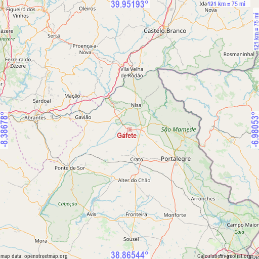
Gáfete GPS coordinates[2]
39° 24' 38.88" North, 7° 41' 1.14" West
| Map corner | latitude | longitude |
|---|---|---|
| Upper-left | 39.95193°, | -8.38678° |
| Center: | 39.4108°, | -7.68365° |
| Lower-right: | 38.86544°, | -6.98053° |
| Map W x H: | 120.8×120.8 km | = 75.1×75.1mi |
| max Lat: | 42.11337° ⇑56% North |
| Gáfete: | 39.4108° |
| min Lat: | ⇓44% South 32.6448° |
| min Long | Gáfete | max Long |
| -31.17847° | -7.68365° | -6.27308° |
| W 88.2%⇐ | ⇒11.8% E |
Elevation
Elevation of Gáfete is 292 m = 958 ft, and this is 115 m = 377 ft above average elevation for this country.
| Max E: |
1008 m = 3307 ft | 19.6% |
| Gáfete | 292 m 958 ft | |
| Avg. | 177 m = 581 ft | |
Min E: |
-128 m = -420 ft | 80.4% |
See also: Portugal elevation on elevation.city.
Geographical zone
Gáfete is located in North temperate zone (between Tropic of Cancer and the Arctic Circle). Distance of this Northern Tropic circle is 1776.2 km =1103.7 mi to South.| Distance of | km | miles | from Gáfete |
|---|---|---|---|
| North Pole | 5625 | 3495.2 | to North |
| Arctic Circle | 3019.1 | 1876 | to North |
| Tropic Cancer | 1776.2 | 1103.7 | to South |
| Equator | 4382.1 | 2722.9 | to South |


Nearby cities:
15 places around Gáfete: (largest is in red/bold)
• Alagoa
13.6 km =8.5 mi,  113°
113°
• Alter do Chão
23.8 km =14.8 mi,  174°
174°
• Atalaia
17 km =10.6 mi,  287°
287°
• Carvoeiro
31.4 km =19.5 mi,  319°
319°
• Castelo de Vide
19.5 km =12.1 mi,  88°
88°
• Comenda
8.5 km =5.3 mi,  261°
261°
• Fortios
18.4 km =11.4 mi,  121°
121°
• Gavião
22.4 km =13.9 mi, 285°
• Marvão
26.4 km =16.4 mi, 94°
• Mação
31.1 km =19.3 mi,  301°
301°
• Nisa
12 km =7.5 mi,  14°
14°
• Portalegre
25.3 km =15.7 mi, 120°
• Póvoa e Meadas
18.1 km =11.2 mi,  52°
52°
• Reguengo
28 km =17.4 mi, 116°
• Vila Velha de Ródão
27.3 km =17 mi,  1°
1°
Sources, notices
• [Note1] Compared only with cities in Portugal existing in our database
• [Src1] Map data: © OpenStreetMap contributors (CC-BY-SA)
• [Src2] Other city data from geonames.org with taken over terms of usage.
• [Src3] Geographical zone / Annual Mean Temperature by Robert A. Rohde @ Wikipedia
