Poceirão geodata
Poceirão (Santarém) is a populated place; located in Portugal in Europe/Lisbon (GMT+1) time zone. With population of 4,225 people, there are 496 cities with bigger population in this country. Compared to other cities in Portugal, 67.8% of cities are located further ↑North; 68.4% of cities are located further →East and 79.8% of cities have higher elevation than Poceirão. Note1


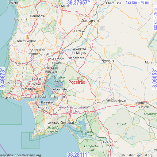
Poceirão GPS coordinates[2]
38° 49' 51.42" North, 8° 47' 37.14" West
| Map corner | latitude | longitude |
|---|---|---|
| Upper-left | 39.37657°, | -9.49678° |
| Center: | 38.83095°, | -8.79365° |
| Lower-right: | 38.28111°, | -8.09053° |
| Map W x H: | 121.8×121.8 km | = 75.7×75.7mi |
| max Lat: | 42.11337° ⇑67.8% North |
| Poceirão: | 38.83095° |
| min Lat: | ⇓32.2% South 32.6448° |
| min Long | Poceirão | max Long |
| -31.17847° | -8.79365° | -6.27308° |
| W 31.6%⇐ | ⇒68.4% E |
Elevation
Elevation of Poceirão is 33 m = 108 ft, and this is 144 m = 472 ft below average elevation for this country.
| Max E: |
1008 m = 3307 ft | 79.8% |
| Avg. | 177 m = 581 ft | |
| Poceirão | 33 m = 108 ft | |
Min E: |
-128 m = -420 ft | 20.2% |
See also: Portugal elevation on elevation.city.
Geographical zone
Poceirão is located in North temperate zone (between Tropic of Cancer and the Arctic Circle). Distance of this Northern Tropic circle is 1711.7 km =1063.6 mi to South.| Distance of | km | miles | from Poceirão |
|---|---|---|---|
| North Pole | 5689.5 | 3535.3 | to North |
| Arctic Circle | 3083.6 | 1916.1 | to North |
| Tropic Cancer | 1711.7 | 1063.6 | to South |
| Equator | 4317.6 | 2682.8 | to South |


Nearby cities:
15 places around Poceirão: (largest is in red/bold)
• Alcochete
16.8 km =10.4 mi,  239°
239°
• Alhandra
21.5 km =13.4 mi,  299°
299°
• Benavente
16.5 km =10.3 mi,  355°
355°
• Castanheira do Ribatejo
23.8 km =14.8 mi,  319°
319°
• Montijo
20.9 km =13 mi,  228°
228°
• Pinhal Novo
24.5 km =15.2 mi,  205°
205°
• Póvoa de Santa Iria
23.7 km =14.7 mi,  278°
278°
• Salvaterra de Magos
21.9 km =13.6 mi,  0°
0°
• Samora Correia
13.6 km =8.5 mi,  330°
330°
• Samouco
22 km =13.7 mi, 236°
• Sarilhos Pequenos
23.3 km =14.5 mi,  224°
224°
• Sobralinho
22.3 km =13.9 mi, 295°
• São João dos Montes
22.9 km =14.2 mi, 301°
• Vialonga
25 km =15.5 mi, 280°
• Vila Franca de Xira
21.9 km =13.6 mi,  309°
309°
Sources, notices
• [Note1] Compared only with cities in Portugal existing in our database
• [Src1] Map data: © OpenStreetMap contributors (CC-BY-SA)
• [Src2] Other city data from geonames.org with taken over terms of usage.
• [Src3] Geographical zone / Annual Mean Temperature by Robert A. Rohde @ Wikipedia
