Ourique geodata
Ourique (Beja) is a seat of a second-order administrative division; located in Portugal in Europe/Lisbon (GMT+1) time zone. In our database, there are 824 cities with bigger population. Compared to other cities in Portugal, 88.9% of cities are located further ↑North; 72.3% of cities are located further ←West and 75.8% of cities have lower elevation than Ourique. Note1


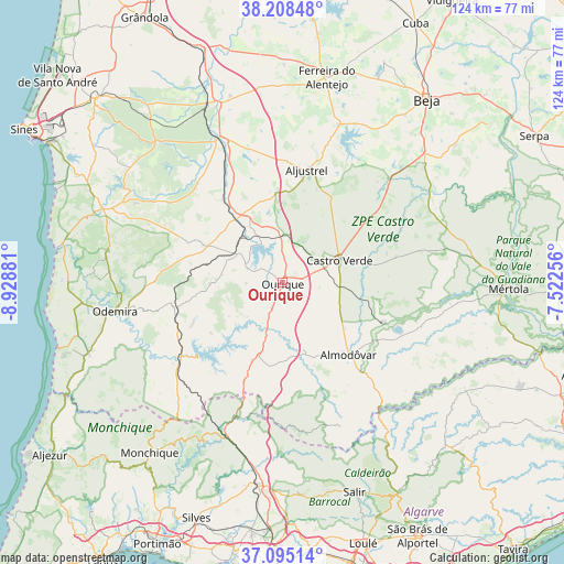
Ourique GPS coordinates[2]
37° 39' 14.04" North, 8° 13' 32.484" West
| Map corner | latitude | longitude |
|---|---|---|
| Upper-left | 38.20848°, | -8.92881° |
| Center: | 37.6539°, | -8.22569° |
| Lower-right: | 37.09514°, | -7.52256° |
| Map W x H: | 123.8×123.8 km | = 76.9×76.9mi |
| max Lat: | 42.11337° ⇑88.9% North |
| Ourique: | 37.6539° |
| min Lat: | ⇓11.1% South 32.6448° |
| min Long | Ourique | max Long |
| -31.17847° | -8.22569° | -6.27308° |
| W 72.3%⇐ | ⇒27.7% E |
Elevation
Elevation of Ourique is 241 m = 791 ft, and this is 64 m = 210 ft above average elevation for this country.
| Max E: |
1008 m = 3307 ft | 24.2% |
| Ourique | 241 m 791 ft | |
| Avg. | 177 m = 581 ft | |
Min E: |
-128 m = -420 ft | 75.8% |
See also: Portugal elevation on elevation.city.
Geographical zone
Ourique is located in North temperate zone (between Tropic of Cancer and the Arctic Circle). Distance of this Northern Tropic circle is 1580.8 km =982.3 mi to South.| Distance of | km | miles | from Ourique |
|---|---|---|---|
| North Pole | 5820.3 | 3616.6 | to North |
| Arctic Circle | 3214.5 | 1997.4 | to North |
| Tropic Cancer | 1580.8 | 982.3 | to South |
| Equator | 4186.7 | 2601.5 | to South |


Nearby cities:
15 places around Ourique: (largest is in red/bold)
• Aljustrel
25.4 km =15.8 mi,  12°
12°
• Almodôvar
21.4 km =13.3 mi,  137°
137°
• Boavista dos Pinheiros
39.5 km =24.5 mi,  258°
258°
• Castro Verde
13.3 km =8.3 mi,  68°
68°
• Cercal
42.7 km =26.5 mi,  292°
292°
• Ferreira do Alentejo
47.2 km =29.3 mi,  20°
20°
• Mombeja
44.3 km =27.5 mi, 21°
• Odemira
37 km =23 mi, 260°
• Penedo Gordo
45.7 km =28.4 mi,  36°
36°
• Santa Clara de Louredo
47 km =29.2 mi, 41°
• Santa Vitória
39.1 km =24.3 mi,  26°
26°
• São Bartolomeu de Messines
44.5 km =27.7 mi,  186°
186°
• São Luis
39.2 km =24.4 mi,  280°
280°
• São Marcos da Serra
35.2 km =21.9 mi,  202°
202°
• São Teotónio
45.2 km =28.1 mi,  249°
249°
Sources, notices
• [Note1] Compared only with cities in Portugal existing in our database
• [Src1] Map data: © OpenStreetMap contributors (CC-BY-SA)
• [Src2] Other city data from geonames.org with taken over terms of usage.
• [Src3] Geographical zone / Annual Mean Temperature by Robert A. Rohde @ Wikipedia
