São Luis geodata
São Luis (Beja) is a populated place; located in Portugal in Europe/Lisbon (GMT+1) time zone. With population of 1,006 people, there are 749 cities with bigger population in this country. Compared to other cities in Portugal, 88.5% of cities are located further ↑North; 59.8% of cities are located further →East and 60.6% of cities have lower elevation than São Luis. Note1


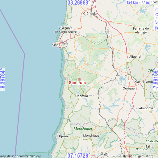
São Luis GPS coordinates[2]
37° 42' 56.016" North, 8° 39' 52.992" West
| Map corner | latitude | longitude |
|---|---|---|
| Upper-left | 38.26968°, | -9.36784° |
| Center: | 37.71556°, | -8.66472° |
| Lower-right: | 37.15726°, | -7.96159° |
| Map W x H: | 123.7×123.7 km | = 76.9×76.9mi |
| max Lat: | 42.11337° ⇑88.5% North |
| São Luis: | 37.71556° |
| min Lat: | ⇓11.5% South 32.6448° |
| min Long | São Luis | max Long |
| -31.17847° | -8.66472° | -6.27308° |
| W 40.2%⇐ | ⇒59.8% E |
Elevation
Elevation of São Luis is 158 m = 518 ft, and this is 19 m = 62 ft below average elevation for this country.
| Max E: |
1008 m = 3307 ft | 39.4% |
| Avg. | 177 m = 581 ft | |
| São Luis | 158 m = 518 ft | |
Min E: |
-128 m = -420 ft | 60.6% |
See also: Portugal elevation on elevation.city.
Geographical zone
São Luis is located in North temperate zone (between Tropic of Cancer and the Arctic Circle). Distance of this Northern Tropic circle is 1587.7 km =986.6 mi to South.| Distance of | km | miles | from São Luis |
|---|---|---|---|
| North Pole | 5813.5 | 3612.3 | to North |
| Arctic Circle | 3207.6 | 1993.1 | to North |
| Tropic Cancer | 1587.7 | 986.6 | to South |
| Equator | 4193.6 | 2605.8 | to South |


Nearby cities:
15 places around São Luis: (largest is in red/bold)
• Almograve
13 km =8.1 mi,  239°
239°
• Boavista dos Pinheiros
15 km =9.3 mi,  179°
179°
• Cercal
9.6 km =6 mi,  355°
355°
• Marmelete
45.1 km =28 mi, 180°
• Monchique
45.3 km =28.1 mi,  167°
167°
• Odeceixe
32.8 km =20.4 mi,  196°
196°
• Odemira
13.3 km =8.3 mi, 170°
• Ourique
39.2 km =24.4 mi,  100°
100°
• Porto Covo
18.8 km =11.7 mi,  324°
324°
• Santiago do Cacém
33.6 km =20.9 mi, 355°
• Santo André
39.7 km =24.7 mi,  344°
344°
• Sines
32.3 km =20.1 mi,  326°
326°
• São Teotónio
22.8 km =14.2 mi,  189°
189°
• Vila Nova de Milfontes
10.4 km =6.5 mi,  275°
275°
• Zambujeira do Mar
23.4 km =14.5 mi,  206°
206°
Sources, notices
• [Note1] Compared only with cities in Portugal existing in our database
• [Src1] Map data: © OpenStreetMap contributors (CC-BY-SA)
• [Src2] Other city data from geonames.org with taken over terms of usage.
• [Src3] Geographical zone / Annual Mean Temperature by Robert A. Rohde @ Wikipedia
