Cercal geodata
Cercal (District of Setúbal) is a populated place; located in Portugal in Europe/Lisbon (GMT+1) time zone. With population of 3,772 people, there are 543 cities with bigger population in this country. Compared to other cities in Portugal, 86.4% of cities are located further ↑North; 61% of cities are located further →East and 57.4% of cities have lower elevation than Cercal. Note1


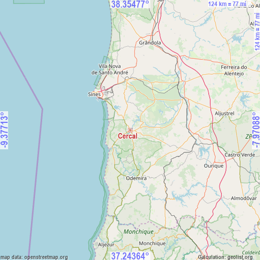
Cercal GPS coordinates[2]
37° 48' 4.644" North, 8° 40' 26.4" West
| Map corner | latitude | longitude |
|---|---|---|
| Upper-left | 38.35477°, | -9.37713° |
| Center: | 37.80129°, | -8.674° |
| Lower-right: | 37.24364°, | -7.97088° |
| Map W x H: | 123.5×123.5 km | = 76.7×76.7mi |
| max Lat: | 42.11337° ⇑86.4% North |
| Cercal: | 37.80129° |
| min Lat: | ⇓13.6% South 32.6448° |
| min Long | Cercal | max Long |
| -31.17847° | -8.674° | -6.27308° |
| W 39%⇐ | ⇒61% E |
Elevation
Elevation of Cercal is 138 m = 453 ft, and this is 39 m = 128 ft below average elevation for this country.
| Max E: |
1008 m = 3307 ft | 42.6% |
| Avg. | 177 m = 581 ft | |
| Cercal | 138 m = 453 ft | |
Min E: |
-128 m = -420 ft | 57.4% |
See also: Portugal elevation on elevation.city.
Geographical zone
Cercal is located in North temperate zone (between Tropic of Cancer and the Arctic Circle). Distance of this Northern Tropic circle is 1597.2 km =992.5 mi to South.| Distance of | km | miles | from Cercal |
|---|---|---|---|
| North Pole | 5804 | 3606.4 | to North |
| Arctic Circle | 3198.1 | 1987.2 | to North |
| Tropic Cancer | 1597.2 | 992.5 | to South |
| Equator | 4203.1 | 2611.7 | to South |


Nearby cities:
15 places around Cercal: (largest is in red/bold)
• Aljustrel
45.5 km =28.3 mi,  79°
79°
• Almograve
19.1 km =11.9 mi,  212°
212°
• Boavista dos Pinheiros
24.6 km =15.3 mi,  178°
178°
• Grândola
42.8 km =26.6 mi,  12°
12°
• Odeceixe
41.8 km =26 mi,  191°
191°
• Odemira
22.8 km =14.2 mi,  172°
172°
• Ourique
42.7 km =26.5 mi,  112°
112°
• Porto Covo
11.7 km =7.3 mi,  299°
299°
• Santiago do Cacém
24 km =14.9 mi,  355°
355°
• Santo André
30.4 km =18.9 mi,  341°
341°
• Sines
24.3 km =15.1 mi,  315°
315°
• São Luis
9.6 km =6 mi, 175°
• São Teotónio
32.2 km =20 mi, 185°
• Vila Nova de Milfontes
12.9 km =8 mi,  227°
227°
• Zambujeira do Mar
31.9 km =19.8 mi,  197°
197°
Sources, notices
• [Note1] Compared only with cities in Portugal existing in our database
• [Src1] Map data: © OpenStreetMap contributors (CC-BY-SA)
• [Src2] Other city data from geonames.org with taken over terms of usage.
• [Src3] Geographical zone / Annual Mean Temperature by Robert A. Rohde @ Wikipedia
