Aljustrel geodata
Aljustrel (Beja) is a seat of a second-order administrative division; located in Portugal in Europe/Lisbon (GMT+0) time zone. With population of 5,334 people, there are 401 cities with bigger population in this country. Compared to other cities in Portugal, 85.2% of cities are located further ↑North; 74.5% of cities are located further ←West and 66% of cities have lower elevation than Aljustrel. Note1


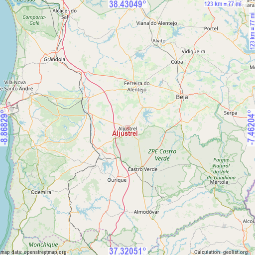
Aljustrel GPS coordinates[2]
37° 52' 39.324" North, 8° 9' 54.576" West
| Map corner | latitude | longitude |
|---|---|---|
| Upper-left | 38.43049°, | -8.86829° |
| Center: | 37.87759°, | -8.16516° |
| Lower-right: | 37.32051°, | -7.46204° |
| Map W x H: | 123.4×123.4 km | = 76.7×76.7mi |
| max Lat: | 42.11337° ⇑85.2% North |
| Aljustrel: | 37.87759° |
| min Lat: | ⇓14.8% South 32.6448° |
| min Long | Aljustrel | max Long |
| -31.17847° | -8.16516° | -6.27308° |
| W 74.5%⇐ | ⇒25.5% E |
Elevation
Elevation of Aljustrel is 182 m = 597 ft, and this is 5 m = 16 ft above average elevation for this country.
| Max E: |
1008 m = 3307 ft | 34% |
| Aljustrel | 182 m 597 ft | |
| Avg. | 177 m = 581 ft | |
Min E: |
-128 m = -420 ft | 66% |
See also: Portugal elevation on elevation.city.
Geographical zone
Aljustrel is located in North temperate zone (between Tropic of Cancer and the Arctic Circle). Distance of this Northern Tropic circle is 1605.7 km =997.7 mi to South.| Distance of | km | miles | from Aljustrel |
|---|---|---|---|
| North Pole | 5795.5 | 3601.2 | to North |
| Arctic Circle | 3189.6 | 1981.9 | to North |
| Tropic Cancer | 1605.7 | 997.7 | to South |
| Equator | 4211.6 | 2617 | to South |


Nearby cities:
15 places around Aljustrel: (largest is in red/bold)
• Beja
30.6 km =19 mi,  59°
59°
• Beringel
25.4 km =15.8 mi,  38°
38°
• Cabeça Gorda
33.1 km =20.6 mi,  81°
81°
• Castro Verde
21.1 km =13.1 mi,  160°
160°
• Faro do Alentejo
36 km =22.4 mi,  32°
32°
• Ferreira do Alentejo
22.4 km =13.9 mi, 31°
• Mombeja
19.7 km =12.2 mi, 34°
• Neves
34.8 km =21.6 mi, 62°
• Ourique
25.4 km =15.8 mi,  192°
192°
• Penedo Gordo
24.9 km =15.5 mi, 61°
• Salvada
34.9 km =21.7 mi, 78°
• Santa Clara de Louredo
27.7 km =17.2 mi,  67°
67°
• Santa Vitória
15.8 km =9.8 mi,  50°
50°
• São Brissos
28.9 km =18 mi, 41°
• Trigaches
29.1 km =18.1 mi, 35°
Sources, notices
• [Note1] Compared only with cities in Portugal existing in our database
• [Src1] Map data: © OpenStreetMap contributors (CC-BY-SA)
• [Src2] Other city data from geonames.org with taken over terms of usage.
• [Src3] Geographical zone / Annual Mean Temperature by Robert A. Rohde @ Wikipedia
