Monte Real geodata
Monte Real (Leiria) is a populated place; located in Portugal in Europe/Lisbon (GMT+1) time zone. With population of 5,756 people, there are 376 cities with bigger population in this country. Compared to other cities in Portugal, 52% of cities are located further ↓South; 70.5% of cities are located further →East and 87.7% of cities have higher elevation than Monte Real. Note1


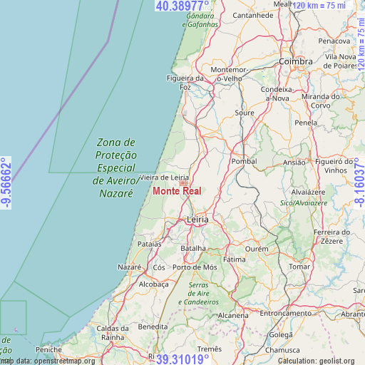
Monte Real GPS coordinates[2]
39° 51' 7.56" North, 8° 51' 48.564" West
| Map corner | latitude | longitude |
|---|---|---|
| Upper-left | 40.38977°, | -9.56662° |
| Center: | 39.8521°, | -8.86349° |
| Lower-right: | 39.31019°, | -8.16037° |
| Map W x H: | 120×120 km | = 74.6×74.6mi |
| max Lat: | 42.11337° ⇑48% North |
| Monte Real: | 39.8521° |
| min Lat: | ⇓52% South 32.6448° |
| min Long | Monte Real | max Long |
| -31.17847° | -8.86349° | -6.27308° |
| W 29.5%⇐ | ⇒70.5% E |
Elevation
Elevation of Monte Real is 20 m = 66 ft, and this is 157 m = 515 ft below average elevation for this country.
| Max E: |
1008 m = 3307 ft | 87.7% |
| Avg. | 177 m = 581 ft | |
| Monte Real | 20 m = 66 ft | |
Min E: |
-128 m = -420 ft | 12.3% |
See also: Portugal elevation on elevation.city.
Geographical zone
Monte Real is located in North temperate zone (between Tropic of Cancer and the Arctic Circle). Distance of this Northern Tropic circle is 1825.2 km =1134.1 mi to South.| Distance of | km | miles | from Monte Real |
|---|---|---|---|
| North Pole | 5575.9 | 3464.7 | to North |
| Arctic Circle | 2970 | 1845.5 | to North |
| Tropic Cancer | 1825.2 | 1134.1 | to South |
| Equator | 4431.1 | 2753.4 | to South |


Nearby cities:
15 places around Monte Real: (largest is in red/bold)
• Amor
5.4 km =3.4 mi,  176°
176°
• Batalha
21.6 km =13.4 mi,  171°
171°
• Caranguejeira
17.8 km =11.1 mi,  131°
131°
• Lavos
27 km =16.8 mi,  6°
6°
• Leiria
13 km =8.1 mi,  158°
158°
• Louriçal
20 km =12.4 mi,  32°
32°
• Maceira
18.4 km =11.4 mi,  188°
188°
• Marinha Grande
13 km =8.1 mi,  206°
206°
• Monte Redondo
5.9 km =3.7 mi, 27°
• Pataias
23.2 km =14.4 mi, 209°
• Pombal
21.3 km =13.2 mi,  70°
70°
• Porto de Mós
28.1 km =17.5 mi, 172°
• Santa Catarina da Serra
24.4 km =15.2 mi,  141°
141°
• Souto da Carpalhosa
2.5 km =1.6 mi,  98°
98°
• Vieira de Leiria
6.2 km =3.9 mi,  288°
288°
Sources, notices
• [Note1] Compared only with cities in Portugal existing in our database
• [Src1] Map data: © OpenStreetMap contributors (CC-BY-SA)
• [Src2] Other city data from geonames.org with taken over terms of usage.
• [Src3] Geographical zone / Annual Mean Temperature by Robert A. Rohde @ Wikipedia
