Caranguejeira geodata
Caranguejeira (Leiria) is a populated place; located in Portugal in Europe/Lisbon (GMT+1) time zone. With population of 5,248 people, there are 406 cities with bigger population in this country. Compared to other cities in Portugal, 51.1% of cities are located further ↓South; 63.2% of cities are located further →East and 55.2% of cities have lower elevation than Caranguejeira. Note1


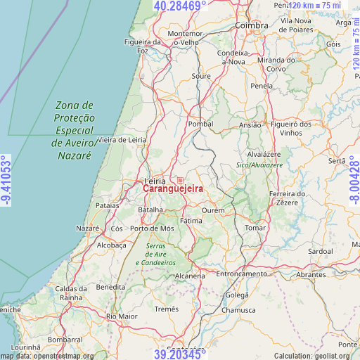
Caranguejeira GPS coordinates[2]
39° 44' 46.284" North, 8° 42' 26.64" West
| Map corner | latitude | longitude |
|---|---|---|
| Upper-left | 40.28469°, | -9.41053° |
| Center: | 39.74619°, | -8.7074° |
| Lower-right: | 39.20345°, | -8.00428° |
| Map W x H: | 120.2×120.2 km | = 74.7×74.7mi |
| max Lat: | 42.11337° ⇑48.9% North |
| Caranguejeira: | 39.74619° |
| min Lat: | ⇓51.1% South 32.6448° |
| min Long | Caranguejeira | max Long |
| -31.17847° | -8.7074° | -6.27308° |
| W 36.8%⇐ | ⇒63.2% E |
Elevation
Elevation of Caranguejeira is 129 m = 423 ft, and this is 48 m = 157 ft below average elevation for this country.
| Max E: |
1008 m = 3307 ft | 44.8% |
| Avg. | 177 m = 581 ft | |
| Caranguejeira | 129 m = 423 ft | |
Min E: |
-128 m = -420 ft | 55.2% |
See also: Portugal elevation on elevation.city.
Geographical zone
Caranguejeira is located in North temperate zone (between Tropic of Cancer and the Arctic Circle). Distance of this Northern Tropic circle is 1813.4 km =1126.8 mi to South.| Distance of | km | miles | from Caranguejeira |
|---|---|---|---|
| North Pole | 5587.7 | 3472 | to North |
| Arctic Circle | 2981.8 | 1852.8 | to North |
| Tropic Cancer | 1813.4 | 1126.8 | to South |
| Equator | 4419.4 | 2746.1 | to South |


Nearby cities:
15 places around Caranguejeira: (largest is in red/bold)
• Amor
14.5 km =9 mi,  296°
296°
• Batalha
13.9 km =8.6 mi,  226°
226°
• Fátima
14.7 km =9.1 mi,  161°
161°
• Leiria
8.5 km =5.3 mi,  268°
268°
• Maceira
17.2 km =10.7 mi,  248°
248°
• Marinha Grande
19.2 km =11.9 mi, 270°
• Mira
22.6 km =14 mi,  181°
181°
• Monte Real
17.8 km =11.1 mi,  311°
311°
• Monte Redondo
20.1 km =12.5 mi,  328°
328°
• Ourém
15.3 km =9.5 mi,  139°
139°
• Pombal
20.1 km =12.5 mi,  19°
19°
• Porto de Mós
18.6 km =11.6 mi,  210°
210°
• Santa Catarina da Serra
7.6 km =4.7 mi,  166°
166°
• Souto da Carpalhosa
15.8 km =9.8 mi,  316°
316°
• Vieira de Leiria
23.6 km =14.7 mi, 305°
Sources, notices
• [Note1] Compared only with cities in Portugal existing in our database
• [Src1] Map data: © OpenStreetMap contributors (CC-BY-SA)
• [Src2] Other city data from geonames.org with taken over terms of usage.
• [Src3] Geographical zone / Annual Mean Temperature by Robert A. Rohde @ Wikipedia
