Leiria geodata
Leiria is a seat of a first-order administrative division; located in Portugal in Europe/Lisbon (GMT+1) time zone. With population of 45,112 people, there are 24 cities with bigger population in this country. Compared to other cities in Portugal, 51% of cities are located further ↓South; 68.8% of cities are located further →East and 79.8% of cities have higher elevation than Leiria. Note1


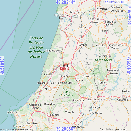
Leiria GPS coordinates[2]
39° 44' 37.032" North, 8° 48' 25.38" West
| Map corner | latitude | longitude |
|---|---|---|
| Upper-left | 40.28214°, | -9.51018° |
| Center: | 39.74362°, | -8.80705° |
| Lower-right: | 39.20086°, | -8.10393° |
| Map W x H: | 120.2×120.2 km | = 74.7×74.7mi |
| max Lat: | 42.11337° ⇑49% North |
| Leiria: | 39.74362° |
| min Lat: | ⇓51% South 32.6448° |
| min Long | Leiria | max Long |
| -31.17847° | -8.80705° | -6.27308° |
| W 31.2%⇐ | ⇒68.8% E |
Elevation
Elevation of Leiria is 33 m = 108 ft, and this is 144 m = 472 ft below average elevation for this country.
| Max E: |
1008 m = 3307 ft | 79.8% |
| Avg. | 177 m = 581 ft | |
| Leiria | 33 m = 108 ft | |
Min E: |
-128 m = -420 ft | 20.2% |
See also: Leiria elevation on elevation.city.
Geographical zone
Leiria is located in North temperate zone (between Tropic of Cancer and the Arctic Circle). Distance of this Northern Tropic circle is 1813.2 km =1126.7 mi to South.| Distance of | km | miles | from Leiria |
|---|---|---|---|
| North Pole | 5588 | 3472.2 | to North |
| Arctic Circle | 2982.1 | 1853 | to North |
| Tropic Cancer | 1813.2 | 1126.7 | to South |
| Equator | 4419.1 | 2745.9 | to South |


Nearby cities:
15 places around Leiria: (largest is in red/bold)
• Aljubarrota
22.2 km =13.8 mi,  208°
208°
• Amor
8.1 km =5 mi,  326°
326°
• Batalha
9.4 km =5.8 mi,  189°
189°
• Caranguejeira
8.5 km =5.3 mi,  88°
88°
• Fátima
19 km =11.8 mi,  135°
135°
• Maceira
9.6 km =6 mi,  230°
230°
• Marinha Grande
10.7 km =6.6 mi,  272°
272°
• Monte Real
13 km =8.1 mi,  338°
338°
• Monte Redondo
17.4 km =10.8 mi,  353°
353°
• Ourém
21.6 km =13.4 mi,  121°
121°
• Pataias
18.1 km =11.2 mi,  243°
243°
• Porto de Mós
15.8 km =9.8 mi,  183°
183°
• Santa Catarina da Serra
12.5 km =7.8 mi, 124°
• Souto da Carpalhosa
11.9 km =7.4 mi, 348°
• Vieira de Leiria
17.6 km =10.9 mi,  322°
322°
Sources, notices
• [Note1] Compared only with cities in Portugal existing in our database
• [Src1] Map data: © OpenStreetMap contributors (CC-BY-SA)
• [Src2] Other city data from geonames.org with taken over terms of usage.
• [Src3] Geographical zone / Annual Mean Temperature by Robert A. Rohde @ Wikipedia
