Pataias geodata
Pataias (Leiria) is a populated place; located in Portugal in Europe/Lisbon (GMT+1) time zone. With population of 5,510 people, there are 393 cities with bigger population in this country. Compared to other cities in Portugal, 50.5% of cities are located further ↓South; 73.8% of cities are located further →East and 54.1% of cities have lower elevation than Pataias. Note1


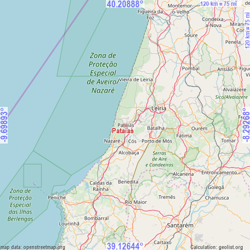
Pataias GPS coordinates[2]
39° 40' 11.208" North, 8° 59' 44.88" West
| Map corner | latitude | longitude |
|---|---|---|
| Upper-left | 40.20888°, | -9.69893° |
| Center: | 39.66978°, | -8.9958° |
| Lower-right: | 39.12644°, | -8.29268° |
| Map W x H: | 120.4×120.4 km | = 74.8×74.8mi |
| max Lat: | 42.11337° ⇑49.5% North |
| Pataias: | 39.66978° |
| min Lat: | ⇓50.5% South 32.6448° |
| min Long | Pataias | max Long |
| -31.17847° | -8.9958° | -6.27308° |
| W 26.2%⇐ | ⇒73.8% E |
Elevation
Elevation of Pataias is 126 m = 413 ft, and this is 51 m = 167 ft below average elevation for this country.
| Max E: |
1008 m = 3307 ft | 45.9% |
| Avg. | 177 m = 581 ft | |
| Pataias | 126 m = 413 ft | |
Min E: |
-128 m = -420 ft | 54.1% |
See also: Portugal elevation on elevation.city.
Geographical zone
Pataias is located in North temperate zone (between Tropic of Cancer and the Arctic Circle). Distance of this Northern Tropic circle is 1804.9 km =1121.5 mi to South.| Distance of | km | miles | from Pataias |
|---|---|---|---|
| North Pole | 5596.2 | 3477.3 | to North |
| Arctic Circle | 2990.3 | 1858.1 | to North |
| Tropic Cancer | 1804.9 | 1121.5 | to South |
| Equator | 4410.9 | 2740.8 | to South |


Nearby cities:
15 places around Pataias: (largest is in red/bold)
• Alcobaça
13.2 km =8.2 mi,  173°
173°
• Alfeizerão
21 km =13 mi,  205°
205°
• Aljubarrota
12.8 km =8 mi,  153°
153°
• Amor
18.9 km =11.7 mi,  37°
37°
• Batalha
14.7 km =9.1 mi,  94°
94°
• Cela
14.7 km =9.1 mi,  193°
193°
• Famalicão
16.6 km =10.3 mi, 206°
• Leiria
18.1 km =11.2 mi,  63°
63°
• Maceira
8.9 km =5.5 mi,  76°
76°
• Marinha Grande
10.2 km =6.3 mi,  32°
32°
• Nazaré
9.7 km =6 mi,  219°
219°
• Porto de Mós
17 km =10.6 mi,  116°
116°
• São Martinho do Porto
20.8 km =12.9 mi, 213°
• Valado de Frades
9.8 km =6.1 mi, 193°
• Vestiaria
13 km =8.1 mi,  180°
180°
Sources, notices
• [Note1] Compared only with cities in Portugal existing in our database
• [Src1] Map data: © OpenStreetMap contributors (CC-BY-SA)
• [Src2] Other city data from geonames.org with taken over terms of usage.
• [Src3] Geographical zone / Annual Mean Temperature by Robert A. Rohde @ Wikipedia
