Funchal geodata
Funchal (Madeira) is a seat of a first-order administrative division; located in Portugal in Atlantic/Madeira (GMT+1) time zone. With population of 100,847 people, there are 7 cities with bigger population in this country. Compared to other cities in Portugal, 99.7% of cities are located further ↑North; 91% of cities are located further →East and 79.4% of cities have lower elevation than Funchal. Note1


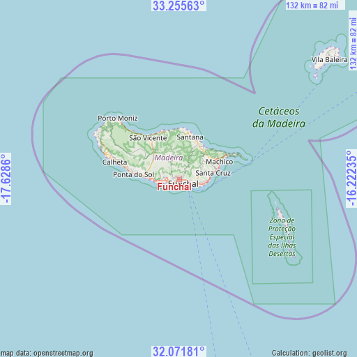
Funchal GPS coordinates[2]
32° 39' 56.448" North, 16° 55' 31.692" West
| Map corner | latitude | longitude |
|---|---|---|
| Upper-left | 33.25563°, | -17.6286° |
| Center: | 32.66568°, | -16.92547° |
| Lower-right: | 32.07181°, | -16.22235° |
| Map W x H: | 131.6×131.6 km | = 81.8×81.8mi |
| max Lat: | 42.11337° ⇑99.7% North |
| Funchal: | 32.66568° |
| min Lat: | ⇓0.3% South 32.6448° |
| min Long | Funchal | max Long |
| -31.17847° | -16.92547° | -6.27308° |
| W 9%⇐ | ⇒91% E |
Elevation
Elevation of Funchal is 280 m = 919 ft, and this is 103 m = 338 ft above average elevation for this country.
| Max E: |
1008 m = 3307 ft | 20.6% |
| Funchal | 280 m 919 ft | |
| Avg. | 177 m = 581 ft | |
Min E: |
-128 m = -420 ft | 79.4% |
See also: Funchal elevation on elevation.city.
Geographical zone
Funchal is located in North temperate zone (between Tropic of Cancer and the Arctic Circle). Distance of this Northern Tropic circle is 1026.2 km =637.7 mi to South.| Distance of | km | miles | from Funchal |
|---|---|---|---|
| North Pole | 6375 | 3961.2 | to North |
| Arctic Circle | 3769.1 | 2342 | to North |
| Tropic Cancer | 1026.2 | 637.7 | to South |
| Equator | 3632.1 | 2256.9 | to South |


Nearby cities:
15 places around Funchal: (largest is in red/bold)
• Camacha
7.7 km =4.8 mi,  78°
78°
• Campanário
10.3 km =6.4 mi,  270°
270°
• Caniço
8.4 km =5.2 mi,  101°
101°
• Curral das Freiras
7.4 km =4.6 mi,  325°
325°
• Câmara de Lobos
5.1 km =3.2 mi,  250°
250°
• Faial
14.9 km =9.3 mi,  28°
28°
• Lugar de Baixo
15.2 km =9.4 mi,  275°
275°
• Nossa Senhora do Monte
2.4 km =1.5 mi,  87°
87°
• Porto da Cruz
14.2 km =8.8 mi,  37°
37°
• Ribeira Brava
12.9 km =8 mi, 274°
• Santa Cruz
12.6 km =7.8 mi, 78°
• Santo da Serra
11.7 km =7.3 mi,  57°
57°
• São Martinho
2.6 km =1.6 mi,  207°
207°
• São Roque
0.8 km =0.5 mi, 82°
• Água de Pena
14.3 km =8.9 mi,  73°
73°
Sources, notices
• [Note1] Compared only with cities in Portugal existing in our database
• [Src1] Map data: © OpenStreetMap contributors (CC-BY-SA)
• [Src2] Other city data from geonames.org with taken over terms of usage.
• [Src3] Geographical zone / Annual Mean Temperature by Robert A. Rohde @ Wikipedia
