Caniço geodata
Caniço (Madeira) is a seat of a third-order administrative division; located in Portugal in Atlantic/Madeira (GMT+1) time zone. With population of 23,368 people, there are 78 cities with bigger population in this country. Compared to other cities in Portugal, 99.8% of cities are located further ↑North; 90.2% of cities are located further →East and 83.7% of cities have lower elevation than Caniço. Note1


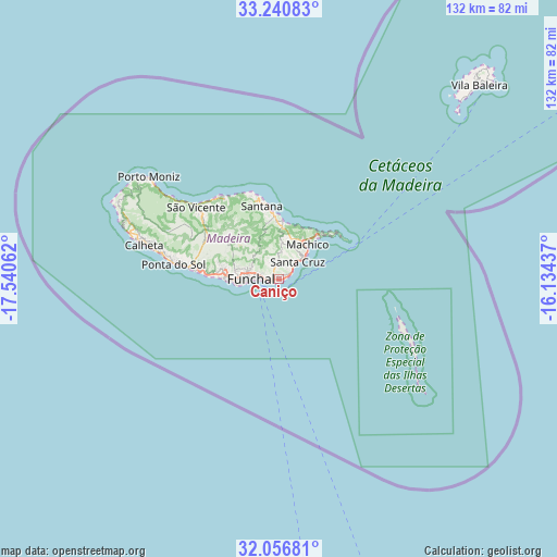
Caniço GPS coordinates[2]
32° 39' 2.808" North, 16° 50' 14.964" West
| Map corner | latitude | longitude |
|---|---|---|
| Upper-left | 33.24083°, | -17.54062° |
| Center: | 32.65078°, | -16.83749° |
| Lower-right: | 32.05681°, | -16.13437° |
| Map W x H: | 131.7×131.7 km | = 81.8×81.8mi |
| max Lat: | 42.11337° ⇑99.8% North |
| Caniço: | 32.65078° |
| min Lat: | ⇓0.2% South 32.6448° |
| min Long | Caniço | max Long |
| -31.17847° | -16.83749° | -6.27308° |
| W 9.8%⇐ | ⇒90.2% E |
Elevation
Elevation of Caniço is 337 m = 1106 ft, and this is 160 m = 525 ft above average elevation for this country.
| Max E: |
1008 m = 3307 ft | 16.3% |
| Caniço | 337 m 1106 ft | |
| Avg. | 177 m = 581 ft | |
Min E: |
-128 m = -420 ft | 83.7% |
See also: Portugal elevation on elevation.city.
Geographical zone
Caniço is located in North temperate zone (between Tropic of Cancer and the Arctic Circle). Distance of this Northern Tropic circle is 1024.5 km =636.6 mi to South.| Distance of | km | miles | from Caniço |
|---|---|---|---|
| North Pole | 6376.6 | 3962.2 | to North |
| Arctic Circle | 3770.7 | 2343 | to North |
| Tropic Cancer | 1024.5 | 636.6 | to South |
| Equator | 3630.4 | 2255.8 | to South |


Nearby cities:
15 places around Caniço: (largest is in red/bold)
• Camacha
3.2 km =2 mi,  348°
348°
• Caniçal
13.4 km =8.3 mi,  43°
43°
• Curral das Freiras
14.6 km =9.1 mi,  301°
301°
• Câmara de Lobos
13.1 km =8.1 mi,  269°
269°
• Faial
14.8 km =9.2 mi,  355°
355°
• Funchal
8.4 km =5.2 mi,  281°
281°
• Machico
9.8 km =6.1 mi, 41°
• Nossa Senhora do Monte
6.1 km =3.8 mi,  286°
286°
• Porto da Cruz
12.9 km =8 mi,  1°
1°
• Santa Cruz
5.8 km =3.6 mi, 44°
• Santana
17.1 km =10.6 mi, 345°
• Santo da Serra
8.1 km =5 mi,  11°
11°
• São Martinho
9.5 km =5.9 mi, 265°
• São Roque
7.6 km =4.7 mi, 283°
• Água de Pena
7.9 km =4.9 mi, 44°
Sources, notices
• [Note1] Compared only with cities in Portugal existing in our database
• [Src1] Map data: © OpenStreetMap contributors (CC-BY-SA)
• [Src2] Other city data from geonames.org with taken over terms of usage.
• [Src3] Geographical zone / Annual Mean Temperature by Robert A. Rohde @ Wikipedia
