Curral das Freiras geodata
Curral das Freiras (Madeira) is a populated place; located in Portugal in Atlantic/Madeira (GMT+1) time zone. With population of 1,673 people, there are 679 cities with bigger population in this country. Compared to other cities in Portugal, 98% of cities are located further ↑North; 91.2% of cities are located further →East and 88.7% of cities have lower elevation than Curral das Freiras. Note1


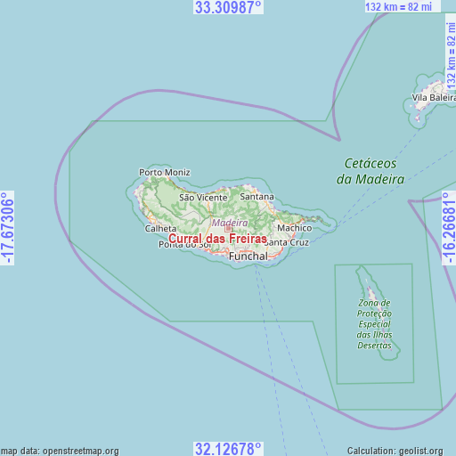
Curral das Freiras GPS coordinates[2]
32° 43' 13.044" North, 16° 58' 11.748" West
| Map corner | latitude | longitude |
|---|---|---|
| Upper-left | 33.30987°, | -17.67306° |
| Center: | 32.72029°, | -16.96993° |
| Lower-right: | 32.12678°, | -16.26681° |
| Map W x H: | 131.5×131.5 km | = 81.7×81.7mi |
| max Lat: | 42.11337° ⇑98% North |
| Curral das Freiras: | 32.72029° |
| min Lat: | ⇓2% South 32.6448° |
| min Long | Curral das Frei | max Long |
| -31.17847° | -16.96993° | -6.27308° |
| W 8.8%⇐ | ⇒91.2% E |
Elevation
Elevation of Curral das Freiras is 435 m = 1427 ft, and this is 258 m = 846 ft above average elevation for this country.
| Max E: |
1008 m = 3307 ft | 11.3% |
| Curral das Freiras | 435 m 1427 ft | |
| Avg. | 177 m = 581 ft | |
Min E: |
-128 m = -420 ft | 88.7% |
See also: Portugal elevation on elevation.city.
Geographical zone
Curral das Freiras is located in North temperate zone (between Tropic of Cancer and the Arctic Circle). Distance of this Northern Tropic circle is 1032.2 km =641.4 mi to South.| Distance of | km | miles | from Curral das Freiras |
|---|---|---|---|
| North Pole | 6368.9 | 3957.4 | to North |
| Arctic Circle | 3763 | 2338.2 | to North |
| Tropic Cancer | 1032.2 | 641.4 | to South |
| Equator | 3638.2 | 2260.7 | to South |


Nearby cities:
15 places around Curral das Freiras: (largest is in red/bold)
• Boaventura
10.9 km =6.8 mi,  358°
358°
• Camacha
12.6 km =7.8 mi,  111°
111°
• Campanário
8.6 km =5.3 mi,  225°
225°
• Canhas
12.4 km =7.7 mi,  256°
256°
• Câmara de Lobos
7.8 km =4.8 mi,  184°
184°
• Funchal
7.4 km =4.6 mi,  145°
145°
• Lugar de Baixo
11.8 km =7.3 mi,  247°
247°
• Nossa Senhora do Monte
8.9 km =5.5 mi,  132°
132°
• Ponta do Sol
13 km =8.1 mi, 249°
• Ribeira Brava
10.1 km =6.3 mi,  239°
239°
• Santana
12 km =7.5 mi,  42°
42°
• São Jorge
12.6 km =7.8 mi,  31°
31°
• São Martinho
8.9 km =5.5 mi,  160°
160°
• São Roque
7.8 km =4.8 mi,  140°
140°
• São Vicente
10.9 km =6.8 mi,  321°
321°
Sources, notices
• [Note1] Compared only with cities in Portugal existing in our database
• [Src1] Map data: © OpenStreetMap contributors (CC-BY-SA)
• [Src2] Other city data from geonames.org with taken over terms of usage.
• [Src3] Geographical zone / Annual Mean Temperature by Robert A. Rohde @ Wikipedia
