Faial geodata
Faial (Madeira) is a populated place; located in Portugal in Atlantic/Madeira (GMT+1) time zone. With population of 1,567 people, there are 687 cities with bigger population in this country. Compared to other cities in Portugal, 97.1% of cities are located further ↑North; 90.4% of cities are located further →East and 100% of cities have higher elevation than Faial. Note1


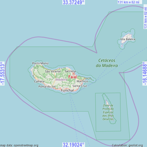
Faial GPS coordinates[2]
32° 46' 59.988" North, 16° 51' 0" West
| Map corner | latitude | longitude |
|---|---|---|
| Upper-left | 33.37249°, | -17.55313° |
| Center: | 32.78333°, | -16.85° |
| Lower-right: | 32.19024°, | -16.14688° |
| Map W x H: | 131.5×131.5 km | = 81.7×81.7mi |
| max Lat: | 42.11337° ⇑97.1% North |
| Faial: | 32.78333° |
| min Lat: | ⇓2.9% South 32.6448° |
| min Long | Faial | max Long |
| -31.17847° | -16.85° | -6.27308° |
| W 9.6%⇐ | ⇒90.4% E |
Elevation
Elevation of Faial is -128 m = -420 ft, and this is 305 m = 1001 ft below average elevation for this country.
| Max E: |
1008 m = 3307 ft | 100% |
| Avg. | 177 m = 581 ft | |
| Faial | -128 m = -420 ft | |
Min E: |
-128 m = -420 ft | 0% |
See also: Portugal elevation on elevation.city.
Geographical zone
Faial is located in North temperate zone (between Tropic of Cancer and the Arctic Circle). Distance of this Northern Tropic circle is 1039.2 km =645.7 mi to South.| Distance of | km | miles | from Faial |
|---|---|---|---|
| North Pole | 6361.9 | 3953.1 | to North |
| Arctic Circle | 3756 | 2333.9 | to North |
| Tropic Cancer | 1039.2 | 645.7 | to South |
| Equator | 3645.2 | 2265 | to South |


Nearby cities:
15 places around Faial: (largest is in red/bold)
• Boaventura
12.1 km =7.5 mi,  288°
288°
• Camacha
11.6 km =7.2 mi,  177°
177°
• Caniçal
11.6 km =7.2 mi,  115°
115°
• Caniço
14.8 km =9.2 mi, 175°
• Curral das Freiras
13.2 km =8.2 mi,  237°
237°
• Funchal
14.9 km =9.3 mi,  208°
208°
• Machico
10.7 km =6.6 mi,  134°
134°
• Nossa Senhora do Monte
13.8 km =8.6 mi,  199°
199°
• Porto da Cruz
2.4 km =1.5 mi,  139°
139°
• Santa Cruz
11.8 km =7.3 mi,  153°
153°
• Santana
3.6 km =2.2 mi,  300°
300°
• Santo da Serra
7.3 km =4.5 mi,  157°
157°
• São Jorge
6 km =3.7 mi,  308°
308°
• São Roque
14.4 km =8.9 mi, 205°
• Água de Pena
11.3 km =7 mi, 143°
Sources, notices
• [Note1] Compared only with cities in Portugal existing in our database
• [Src1] Map data: © OpenStreetMap contributors (CC-BY-SA)
• [Src2] Other city data from geonames.org with taken over terms of usage.
• [Src3] Geographical zone / Annual Mean Temperature by Robert A. Rohde @ Wikipedia
