Camacha geodata
Camacha (Madeira) is a populated place; located in Portugal in Atlantic/Madeira (GMT+1) time zone. With population of 7,991 people, there are 279 cities with bigger population in this country. Compared to other cities in Portugal, 99.1% of cities are located further ↑North; 90.3% of cities are located further →East and 97.3% of cities have lower elevation than Camacha. Note1


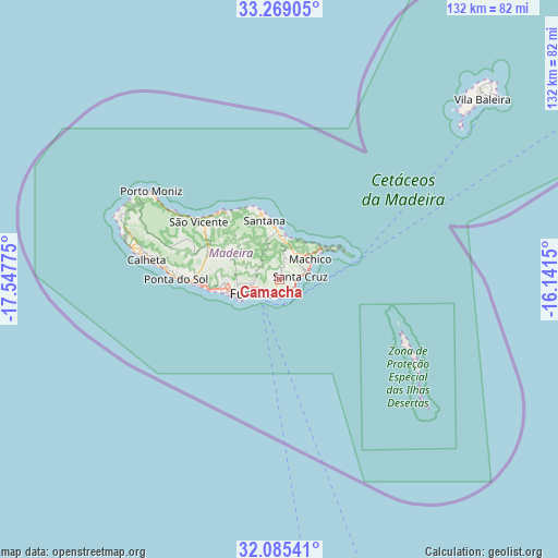
Camacha GPS coordinates[2]
32° 40' 45.084" North, 16° 50' 40.632" West
| Map corner | latitude | longitude |
|---|---|---|
| Upper-left | 33.26905°, | -17.54775° |
| Center: | 32.67919°, | -16.84462° |
| Lower-right: | 32.08541°, | -16.1415° |
| Map W x H: | 131.6×131.6 km | = 81.8×81.8mi |
| max Lat: | 42.11337° ⇑99.1% North |
| Camacha: | 32.67919° |
| min Lat: | ⇓0.9% South 32.6448° |
| min Long | Camacha | max Long |
| -31.17847° | -16.84462° | -6.27308° |
| W 9.7%⇐ | ⇒90.3% E |
Elevation
Elevation of Camacha is 703 m = 2306 ft, and this is 526 m = 1726 ft above average elevation for this country.
| Max E: |
1008 m = 3307 ft | 2.7% |
| Camacha | 703 m 2306 ft | |
| Avg. | 177 m = 581 ft | |
Min E: |
-128 m = -420 ft | 97.3% |
See also: Portugal elevation on elevation.city.
Geographical zone
Camacha is located in North temperate zone (between Tropic of Cancer and the Arctic Circle). Distance of this Northern Tropic circle is 1027.7 km =638.6 mi to South.| Distance of | km | miles | from Camacha |
|---|---|---|---|
| North Pole | 6373.5 | 3960.3 | to North |
| Arctic Circle | 3767.6 | 2341.1 | to North |
| Tropic Cancer | 1027.7 | 638.6 | to South |
| Equator | 3633.6 | 2257.8 | to South |


Nearby cities:
15 places around Camacha: (largest is in red/bold)
• Caniçal
11.9 km =7.4 mi,  56°
56°
• Caniço
3.2 km =2 mi,  168°
168°
• Curral das Freiras
12.6 km =7.8 mi,  291°
291°
• Câmara de Lobos
12.8 km =8 mi,  255°
255°
• Faial
11.6 km =7.2 mi,  357°
357°
• Funchal
7.7 km =4.8 mi, 258°
• Machico
8.3 km =5.2 mi, 60°
• Nossa Senhora do Monte
5.4 km =3.4 mi,  254°
254°
• Porto da Cruz
9.8 km =6.1 mi,  6°
6°
• Santa Cruz
4.8 km =3 mi,  78°
78°
• Santana
13.9 km =8.6 mi,  344°
344°
• Santo da Serra
5.3 km =3.3 mi,  25°
25°
• São Martinho
9.6 km =6 mi, 246°
• São Roque
6.9 km =4.3 mi, 258°
• Água de Pena
6.6 km =4.1 mi,  68°
68°
Sources, notices
• [Note1] Compared only with cities in Portugal existing in our database
• [Src1] Map data: © OpenStreetMap contributors (CC-BY-SA)
• [Src2] Other city data from geonames.org with taken over terms of usage.
• [Src3] Geographical zone / Annual Mean Temperature by Robert A. Rohde @ Wikipedia
