Sertã geodata
Sertã (Castelo Branco) is a seat of a second-order administrative division; located in Portugal in Europe/Lisbon (GMT+1) time zone. With population of 5,636 people, there are 383 cities with bigger population in this country. Compared to other cities in Portugal, 51.5% of cities are located further ↓South; 76.7% of cities are located further ←West and 77.9% of cities have lower elevation than Sertã. Note1


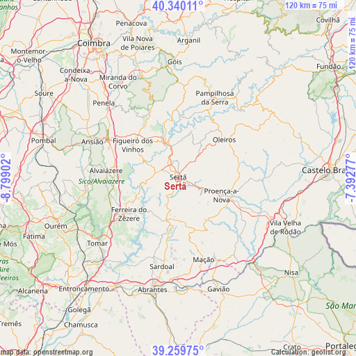
Sertã GPS coordinates[2]
39° 48' 7.38" North, 8° 5' 45.204" West
| Map corner | latitude | longitude |
|---|---|---|
| Upper-left | 40.34011°, | -8.79902° |
| Center: | 39.80205°, | -8.09589° |
| Lower-right: | 39.25975°, | -7.39277° |
| Map W x H: | 120.1×120.1 km | = 74.6×74.6mi |
| max Lat: | 42.11337° ⇑48.5% North |
| Sertã: | 39.80205° |
| min Lat: | ⇓51.5% South 32.6448° |
| min Long | Sertã | max Long |
| -31.17847° | -8.09589° | -6.27308° |
| W 76.7%⇐ | ⇒23.3% E |
Elevation
Elevation of Sertã is 262 m = 860 ft, and this is 85 m = 279 ft above average elevation for this country.
| Max E: |
1008 m = 3307 ft | 22.1% |
| Sertã | 262 m 860 ft | |
| Avg. | 177 m = 581 ft | |
Min E: |
-128 m = -420 ft | 77.9% |
See also: Portugal elevation on elevation.city.
Geographical zone
Sertã is located in North temperate zone (between Tropic of Cancer and the Arctic Circle). Distance of this Northern Tropic circle is 1819.7 km =1130.7 mi to South.| Distance of | km | miles | from Sertã |
|---|---|---|---|
| North Pole | 5581.5 | 3468.2 | to North |
| Arctic Circle | 2975.6 | 1849 | to North |
| Tropic Cancer | 1819.7 | 1130.7 | to South |
| Equator | 4425.6 | 2749.9 | to South |


Nearby cities:
15 places around Sertã: (largest is in red/bold)
• Alvaiázere
24.4 km =15.2 mi,  275°
275°
• Ansião
31.5 km =19.6 mi,  292°
292°
• Carvoeiro
24.6 km =15.3 mi,  143°
143°
• Castanheira de Pêra
24.8 km =15.4 mi,  336°
336°
• Ferreira do Zêzere
20.6 km =12.8 mi,  234°
234°
• Figueiró dos Vinhos
19 km =11.8 mi,  306°
306°
• Fontes
24.6 km =15.3 mi,  208°
208°
• Mação
28.7 km =17.8 mi,  162°
162°
• Oleiros
20.3 km =12.6 mi,  50°
50°
• Pampilhosa da Serra
29.8 km =18.5 mi,  24°
24°
• Pedrógão Grande
13.6 km =8.5 mi, 341°
• Proença-a-Nova
15.7 km =9.8 mi,  110°
110°
• Sardoal
30.3 km =18.8 mi,  190°
190°
• Tomar
34.8 km =21.6 mi, 230°
• Vila de Rei
14.6 km =9.1 mi,  196°
196°
Sources, notices
• [Note1] Compared only with cities in Portugal existing in our database
• [Src1] Map data: © OpenStreetMap contributors (CC-BY-SA)
• [Src2] Other city data from geonames.org with taken over terms of usage.
• [Src3] Geographical zone / Annual Mean Temperature by Robert A. Rohde @ Wikipedia
