Alvaiázere geodata
Alvaiázere (Leiria) is a seat of a second-order administrative division; located in Portugal in Europe/Lisbon (GMT+1) time zone. In our database, there are 824 cities with bigger population. Compared to other cities in Portugal, 51.8% of cities are located further ↓South; 64.5% of cities are located further ←West and 82% of cities have lower elevation than Alvaiázere. Note1


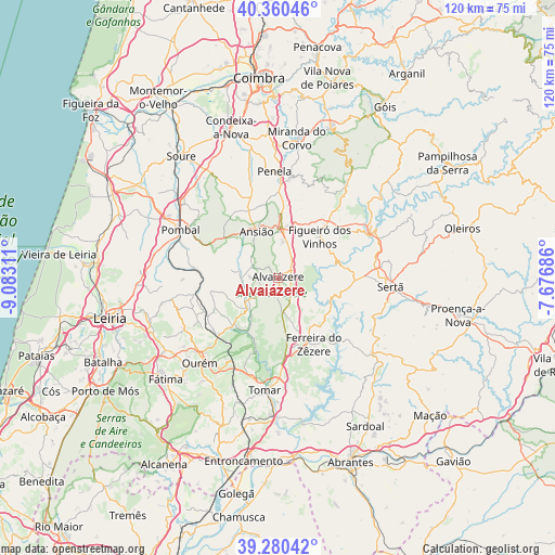
Alvaiázere GPS coordinates[2]
39° 49' 21.216" North, 8° 22' 47.964" West
| Map corner | latitude | longitude |
|---|---|---|
| Upper-left | 40.36046°, | -9.08311° |
| Center: | 39.82256°, | -8.37999° |
| Lower-right: | 39.28042°, | -7.67686° |
| Map W x H: | 120.1×120.1 km | = 74.6×74.6mi |
| max Lat: | 42.11337° ⇑48.2% North |
| Alvaiázere: | 39.82256° |
| min Lat: | ⇓51.8% South 32.6448° |
| min Long | Alvaiázere | max Long |
| -31.17847° | -8.37999° | -6.27308° |
| W 64.5%⇐ | ⇒35.5% E |
Elevation
Elevation of Alvaiázere is 311 m = 1020 ft, and this is 134 m = 440 ft above average elevation for this country.
| Max E: |
1008 m = 3307 ft | 18% |
| Alvaiázere | 311 m 1020 ft | |
| Avg. | 177 m = 581 ft | |
Min E: |
-128 m = -420 ft | 82% |
See also: Portugal elevation on elevation.city.
Geographical zone
Alvaiázere is located in North temperate zone (between Tropic of Cancer and the Arctic Circle). Distance of this Northern Tropic circle is 1821.9 km =1132.1 mi to South.| Distance of | km | miles | from Alvaiázere |
|---|---|---|---|
| North Pole | 5579.2 | 3466.8 | to North |
| Arctic Circle | 2973.3 | 1847.5 | to North |
| Tropic Cancer | 1821.9 | 1132.1 | to South |
| Equator | 4427.9 | 2751.4 | to South |


Nearby cities:
15 places around Alvaiázere: (largest is in red/bold)
• Ansião
11 km =6.8 mi,  334°
334°
• Caranguejeira
29.2 km =18.1 mi,  253°
253°
• Castanheira de Pêra
25.1 km =15.6 mi,  35°
35°
• Ferreira do Zêzere
16.1 km =10 mi,  152°
152°
• Figueiró dos Vinhos
12.7 km =7.9 mi, 44°
• Fontes
27.2 km =16.9 mi, 152°
• Madalena
28.5 km =17.7 mi,  191°
191°
• Ourém
27.1 km =16.8 mi,  222°
222°
• Paialvo
29.7 km =18.5 mi, 194°
• Pedrógão Grande
22.6 km =14 mi,  61°
61°
• Penela
23.4 km =14.5 mi,  359°
359°
• Pombal
23.6 km =14.7 mi,  296°
296°
• Sertã
24.4 km =15.2 mi,  95°
95°
• Tomar
24.7 km =15.3 mi, 185°
• Vila de Rei
25.8 km =16 mi,  129°
129°
Sources, notices
• [Note1] Compared only with cities in Portugal existing in our database
• [Src1] Map data: © OpenStreetMap contributors (CC-BY-SA)
• [Src2] Other city data from geonames.org with taken over terms of usage.
• [Src3] Geographical zone / Annual Mean Temperature by Robert A. Rohde @ Wikipedia
