Portimão geodata
Portimão (Faro) is a populated place; located in Portugal in Europe/Lisbon (GMT+0) time zone. With population of 38,487 people, there are 31 cities with bigger population in this country. Compared to other cities in Portugal, 92.3% of cities are located further ↑North; 52.1% of cities are located further ←West and 92.5% of cities have higher elevation than Portimão. Note1


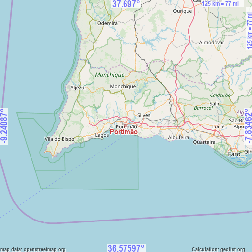
Portimão GPS coordinates[2]
37° 8' 18.816" North, 8° 32' 15.9" West
| Map corner | latitude | longitude |
|---|---|---|
| Upper-left | 37.697°, | -9.24087° |
| Center: | 37.13856°, | -8.53775° |
| Lower-right: | 36.57597°, | -7.83462° |
| Map W x H: | 124.6×124.6 km | = 77.4×77.4mi |
| max Lat: | 42.11337° ⇑92.3% North |
| Portimão: | 37.13856° |
| min Lat: | ⇓7.7% South 32.6448° |
| min Long | Portimão | max Long |
| -31.17847° | -8.53775° | -6.27308° |
| W 52.1%⇐ | ⇒47.9% E |
Elevation
Elevation of Portimão is 13 m = 43 ft, and this is 164 m = 538 ft below average elevation for this country.
| Max E: |
1008 m = 3307 ft | 92.5% |
| Avg. | 177 m = 581 ft | |
| Portimão | 13 m = 43 ft | |
Min E: |
-128 m = -420 ft | 7.5% |
See also: Portugal elevation on elevation.city.
Geographical zone
Portimão is located in North temperate zone (between Tropic of Cancer and the Arctic Circle). Distance of this Northern Tropic circle is 1523.5 km =946.7 mi to South.| Distance of | km | miles | from Portimão |
|---|---|---|---|
| North Pole | 5877.6 | 3652.2 | to North |
| Arctic Circle | 3271.8 | 2033 | to North |
| Tropic Cancer | 1523.5 | 946.7 | to South |
| Equator | 4129.4 | 2565.9 | to South |


Nearby cities:
15 places around Portimão: (largest is in red/bold)
• Alcantarilha
17 km =10.6 mi,  93°
93°
• Alvor
4.9 km =3 mi,  258°
258°
• Armação de Pêra
16.5 km =10.3 mi,  104°
104°
• Bensafrim
17.6 km =10.9 mi,  276°
276°
• Carvoeiro
7.7 km =4.8 mi,  126°
126°
• Estômbar
4.7 km =2.9 mi,  79°
79°
• Ferragudo
2.3 km =1.4 mi, 132°
• Lagoa
7.5 km =4.7 mi, 92°
• Lagos
12.8 km =8 mi,  251°
251°
• Mexilhoeira Grande
7.2 km =4.5 mi,  288°
288°
• Parchal
1.8 km =1.1 mi, 91°
• Porches
12.1 km =7.5 mi, 96°
• Pêra
17.5 km =10.9 mi, 95°
• Senhora da Luz
17.7 km =11 mi, 251°
• Silves
10.5 km =6.5 mi,  57°
57°
Sources, notices
• [Note1] Compared only with cities in Portugal existing in our database
• [Src1] Map data: © OpenStreetMap contributors (CC-BY-SA)
• [Src2] Other city data from geonames.org with taken over terms of usage.
• [Src3] Geographical zone / Annual Mean Temperature by Robert A. Rohde @ Wikipedia
