Arronches geodata
Arronches (Portalegre) is a seat of a second-order administrative division; located in Portugal in Europe/Lisbon (GMT+1) time zone. With population of 3,165 people, there are 580 cities with bigger population in this country. Compared to other cities in Portugal, 61.9% of cities are located further ↑North; 96.7% of cities are located further ←West and 80.4% of cities have lower elevation than Arronches. Note1


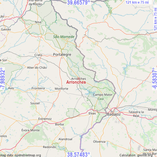
Arronches GPS coordinates[2]
39° 7' 20.712" North, 7° 17' 10.284" West
| Map corner | latitude | longitude |
|---|---|---|
| Upper-left | 39.66579°, | -7.98932° |
| Center: | 39.12242°, | -7.28619° |
| Lower-right: | 38.57483°, | -6.58307° |
| Map W x H: | 121.3×121.3 km | = 75.4×75.4mi |
| max Lat: | 42.11337° ⇑61.9% North |
| Arronches: | 39.12242° |
| min Lat: | ⇓38.1% South 32.6448° |
| min Long | Arronches | max Long |
| -31.17847° | -7.28619° | -6.27308° |
| W 96.7%⇐ | ⇒3.3% E |
Elevation
Elevation of Arronches is 292 m = 958 ft, and this is 115 m = 377 ft above average elevation for this country.
| Max E: |
1008 m = 3307 ft | 19.6% |
| Arronches | 292 m 958 ft | |
| Avg. | 177 m = 581 ft | |
Min E: |
-128 m = -420 ft | 80.4% |
See also: Portugal elevation on elevation.city.
Geographical zone
Arronches is located in North temperate zone (between Tropic of Cancer and the Arctic Circle). Distance of this Northern Tropic circle is 1744.1 km =1083.7 mi to South.| Distance of | km | miles | from Arronches |
|---|---|---|---|
| North Pole | 5657.1 | 3515.2 | to North |
| Arctic Circle | 3051.2 | 1895.9 | to North |
| Tropic Cancer | 1744.1 | 1083.7 | to South |
| Equator | 4350 | 2703 | to South |


Nearby cities:
15 places around Arronches: (largest is in red/bold)
• Alagoa
34.3 km =21.3 mi,  320°
320°
• Alegrete
13.4 km =8.3 mi,  346°
346°
• Alter do Chão
33.2 km =20.6 mi,  284°
284°
• Campo Maior
22.4 km =13.9 mi,  121°
121°
• Castelo de Vide
35.8 km =22.2 mi,  335°
335°
• Elvas
28.8 km =17.9 mi,  158°
158°
• Fortios
29.1 km =18.1 mi, 320°
• Fronteira
32.1 km =19.9 mi,  256°
256°
• Marvão
31.2 km =19.4 mi, 345°
• Monforte
15.1 km =9.4 mi,  239°
239°
• Portalegre
22.8 km =14.2 mi,  326°
326°
• Reguengo
21.6 km =13.4 mi, 334°
• São Julião
22.4 km =13.9 mi, 354°
• Urra
15.2 km =9.4 mi, 320°
• Vale da Amoreira
36.1 km =22.4 mi, 260°
Sources, notices
• [Note1] Compared only with cities in Portugal existing in our database
• [Src1] Map data: © OpenStreetMap contributors (CC-BY-SA)
• [Src2] Other city data from geonames.org with taken over terms of usage.
• [Src3] Geographical zone / Annual Mean Temperature by Robert A. Rohde @ Wikipedia
