Marvão geodata
Marvão (Portalegre) is a populated place; located in Portugal in Europe/Lisbon (GMT+1) time zone. With population of 3,739 people, there are 548 cities with bigger population in this country. Compared to other cities in Portugal, 56.4% of cities are located further ↑North; 95.7% of cities are located further ←West and 99.3% of cities have lower elevation than Marvão. Note1


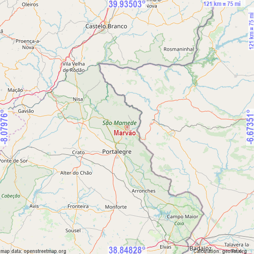
Marvão GPS coordinates[2]
39° 23' 37.572" North, 7° 22' 35.868" West
| Map corner | latitude | longitude |
|---|---|---|
| Upper-left | 39.93503°, | -8.07976° |
| Center: | 39.39377°, | -7.37663° |
| Lower-right: | 38.84828°, | -6.67351° |
| Map W x H: | 120.8×120.8 km | = 75.1×75.1mi |
| max Lat: | 42.11337° ⇑56.4% North |
| Marvão: | 39.39377° |
| min Lat: | ⇓43.6% South 32.6448° |
| min Long | Marvão | max Long |
| -31.17847° | -7.37663° | -6.27308° |
| W 95.7%⇐ | ⇒4.3% E |
Elevation
Elevation of Marvão is 825 m = 2707 ft, and this is 648 m = 2126 ft above average elevation for this country.
| Max E: |
1008 m = 3307 ft | 0.7% |
| Marvão | 825 m 2707 ft | |
| Avg. | 177 m = 581 ft | |
Min E: |
-128 m = -420 ft | 99.3% |
See also: Portugal elevation on elevation.city.
Geographical zone
Marvão is located in North temperate zone (between Tropic of Cancer and the Arctic Circle). Distance of this Northern Tropic circle is 1774.3 km =1102.5 mi to South.| Distance of | km | miles | from Marvão |
|---|---|---|---|
| North Pole | 5626.9 | 3496.4 | to North |
| Arctic Circle | 3021 | 1877.2 | to North |
| Tropic Cancer | 1774.3 | 1102.5 | to South |
| Equator | 4380.2 | 2721.7 | to South |


Nearby cities:
15 places around Marvão: (largest is in red/bold)
• Alagoa
14.4 km =8.9 mi,  255°
255°
• Alegrete
17.7 km =11 mi,  165°
165°
• Alter do Chão
32.7 km =20.3 mi,  228°
228°
• Arronches
31.2 km =19.4 mi, 165°
• Castelo de Vide
7.3 km =4.5 mi,  289°
289°
• Comenda
34.8 km =21.6 mi,  271°
271°
• Fortios
13.1 km =8.1 mi, 234°
• Gáfete
26.4 km =16.4 mi, 274°
• Monforte
38.2 km =23.7 mi,  187°
187°
• Nisa
27 km =16.8 mi,  299°
299°
• Portalegre
12.1 km =7.5 mi,  202°
202°
• Póvoa e Meadas
17.7 km =11 mi,  316°
316°
• Reguengo
10.7 km =6.6 mi, 187°
• São Julião
9.7 km =6 mi,  144°
144°
• Urra
18.5 km =11.5 mi, 185°
Sources, notices
• [Note1] Compared only with cities in Portugal existing in our database
• [Src1] Map data: © OpenStreetMap contributors (CC-BY-SA)
• [Src2] Other city data from geonames.org with taken over terms of usage.
• [Src3] Geographical zone / Annual Mean Temperature by Robert A. Rohde @ Wikipedia
