Castelo de Vide geodata
Castelo de Vide (Portalegre) is a populated place; located in Portugal in Europe/Lisbon (GMT+1) time zone. With population of 3,780 people, there are 539 cities with bigger population in this country. Compared to other cities in Portugal, 55.8% of cities are located further ↑North; 93.4% of cities are located further ←West and 93.7% of cities have lower elevation than Castelo de Vide. Note1
Administrative division(s):
- Level 1: Portalegre
- Level 2: Castelo de Vide
- Level 3: Santa Maria da Devesa


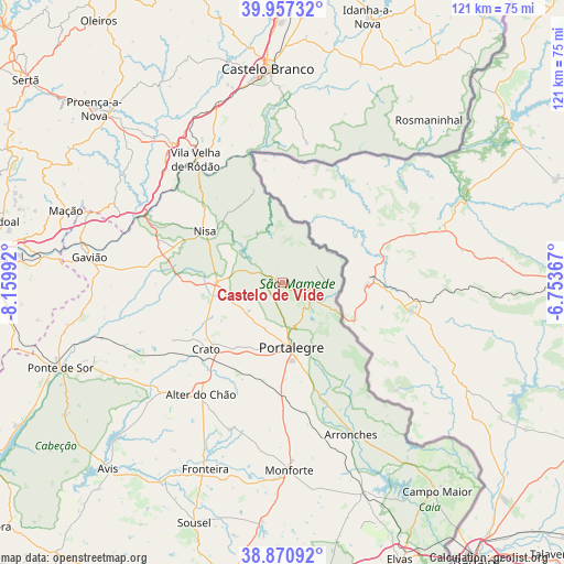
Castelo de Vide GPS coordinates[2]
39° 24' 58.464" North, 7° 27' 24.48" West
| Map corner | latitude | longitude |
|---|---|---|
| Upper-left | 39.95732°, | -8.15992° |
| Center: | 39.41624°, | -7.4568° |
| Lower-right: | 38.87092°, | -6.75367° |
| Map W x H: | 120.8×120.8 km | = 75.1×75.1mi |
| max Lat: | 42.11337° ⇑55.8% North |
| Castelo de Vide: | 39.41624° |
| min Lat: | ⇓44.2% South 32.6448° |
| min Long | Castelo de Vide | max Long |
| -31.17847° | -7.4568° | -6.27308° |
| W 93.4%⇐ | ⇒6.6% E |
Elevation
Elevation of Castelo de Vide is 570 m = 1870 ft, and this is 393 m = 1289 ft above average elevation for this country.
| Max E: |
1008 m = 3307 ft | 6.3% |
| Castelo de Vide | 570 m 1870 ft | |
| Avg. | 177 m = 581 ft | |
Min E: |
-128 m = -420 ft | 93.7% |
See also: Portugal elevation on elevation.city.
Geographical zone
Castelo de Vide is located in North temperate zone (between Tropic of Cancer and the Arctic Circle). Distance of this Northern Tropic circle is 1776.8 km =1104.1 mi to South.| Distance of | km | miles | from Castelo de Vide |
|---|---|---|---|
| North Pole | 5624.4 | 3494.8 | to North |
| Arctic Circle | 3018.5 | 1875.6 | to North |
| Tropic Cancer | 1776.8 | 1104.1 | to South |
| Equator | 4382.7 | 2723.3 | to South |


Nearby cities:
15 places around Castelo de Vide: (largest is in red/bold)
• Alagoa
9.3 km =5.8 mi,  229°
229°
• Alegrete
22.7 km =14.1 mi,  149°
149°
• Alter do Chão
29.9 km =18.6 mi,  215°
215°
• Arronches
35.8 km =22.2 mi,  155°
155°
• Comenda
27.9 km =17.3 mi,  266°
266°
• Fortios
10.8 km =6.7 mi,  200°
200°
• Gáfete
19.5 km =12.1 mi, 268°
• Marvão
7.3 km =4.5 mi,  109°
109°
• Nisa
19.8 km =12.3 mi,  303°
303°
• Portalegre
13.8 km =8.6 mi,  170°
170°
• Póvoa e Meadas
11.7 km =7.3 mi,  333°
333°
• Reguengo
14.3 km =8.9 mi, 157°
• São Julião
16.3 km =10.1 mi,  129°
129°
• Urra
21.5 km =13.4 mi, 166°
• Vila Velha de Ródão
32.7 km =20.3 mi,  324°
324°
Sources, notices
• [Note1] Compared only with cities in Portugal existing in our database
• [Src1] Map data: © OpenStreetMap contributors (CC-BY-SA)
• [Src2] Other city data from geonames.org with taken over terms of usage.
• [Src3] Geographical zone / Annual Mean Temperature by Robert A. Rohde @ Wikipedia
